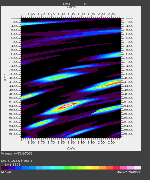
LCCR Mulino, OR, USA - Earthquake Result Viewer

Earthquake location: Near East Coast Of Honshu, Japan
Earthquake latitude/longitude: 37.7/141.7
Earthquake time(UTC): 2011/08/19 (231) 05:36:33 GMT
Earthquake Depth: 47 km
Earthquake Magnitude: 6.3 MB, 5.9 MS, 6.3 MW, 6.3 MW
Earthquake Catalog/Contributor: WHDF/NEIC
Network: UW Pacific Northwest Regional Seismic Network
Station: LCCR Mulino, OR, USA
Lat/Lon: 45.21 N/122.48 W
Elevation: 273 m
Distance: 68.1 deg
Az: 49.284 deg
Baz: 301.705 deg
Ray Param: 0.056435246
Estimated Moho Depth: 53.5 km
Estimated Crust Vp/Vs: 1.83
Assumed Crust Vp: 6.566 km/s
Estimated Crust Vs: 3.583 km/s
Estimated Crust Poisson's Ratio: 0.29
Radial Match: 85.60506 %
Radial Bump: 400
Transverse Match: 77.602905 %
Transverse Bump: 400
SOD ConfigId: 410809
Insert Time: 2012-01-06 09:51:24.093 +0000
GWidth: 2.5
Max Bumps: 400
Tol: 0.001

Signal To Noise

ChannelStoNSTALTA
UW:LCCR: :BHZ:20110819T05:46:57.125022Z23.5736353.563005E-61.5114364E-7
UW:LCCR: :BHN:20110819T05:46:57.125022Z2.25133925.991574E-72.6613378E-7
UW:LCCR: :BHE:20110819T05:46:57.125022Z3.51658759.745594E-72.7713213E-7
Arrivals
Ps7.1 SECOND
PpPs22 SECOND
PsPs/PpSs29 SECOND