You are here: Home > Network List > CI - Caltech Regional Seismic Network Stations List
> Station SHO Shoshone, CA, USA > Earthquake Result Viewer
SHO Shoshone, CA, USA - Earthquake Result Viewer
| Earthquake location: |
Vanuatu Islands |
| Earthquake latitude/longitude: |
-18.4/168.1 |
| Earthquake time(UTC): |
2011/08/20 (232) 16:55:02 GMT |
| Earthquake Depth: |
32 km |
| Earthquake Magnitude: |
6.2 MB, 7.1 MS, 7.1 MW, 7.0 MW |
| Earthquake Catalog/Contributor: |
WHDF/NEIC |
|
| Network: |
CI Caltech Regional Seismic Network |
| Station: |
SHO Shoshone, CA, USA |
| Lat/Lon: |
35.90 N/116.28 W |
| Elevation: |
451 m |
|
| Distance: |
89.5 deg |
| Az: |
51.848 deg |
| Baz: |
246.9 deg |
| Ray Param: |
0.041784745 |
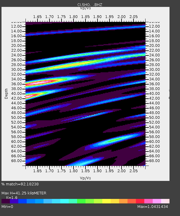
| Estimated Moho Depth: |
41.25 km |
| Estimated Crust Vp/Vs: |
1.60 |
| Assumed Crust Vp: |
6.276 km/s |
| Estimated Crust Vs: |
3.922 km/s |
| Estimated Crust Poisson's Ratio: |
0.18 |
|
| Radial Match: |
92.18238 % |
| Radial Bump: |
400 |
| Transverse Match: |
75.77919 % |
| Transverse Bump: |
400 |
| SOD ConfigId: |
414626 |
| Insert Time: |
2012-01-13 05:01:05.492 +0000 |
| GWidth: |
2.5 |
| Max Bumps: |
400 |
| Tol: |
0.001 |
|
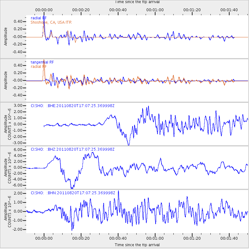
Signal To Noise
| Channel | StoN | STA | LTA |
| CI:SHO: :BHZ:20110820T17:07:25.369998Z | 17.735647 | 1.5040665E-6 | 8.480471E-8 |
| CI:SHO: :BHN:20110820T17:07:25.369998Z | 1.8565298 | 2.0648977E-7 | 1.11223514E-7 |
| CI:SHO: :BHE:20110820T17:07:25.369998Z | 5.8148904 | 5.746419E-7 | 9.8822476E-8 |
| Arrivals |
| Ps | 4.0 SECOND |
| PpPs | 17 SECOND |
| PsPs/PpSs | 21 SECOND |


