You are here: Home > Network List > CI - Caltech Regional Seismic Network Stations List
> Station FUR Furnace Creek, CA, USA > Earthquake Result Viewer
FUR Furnace Creek, CA, USA - Earthquake Result Viewer
| Earthquake location: |
Vanuatu Islands |
| Earthquake latitude/longitude: |
-18.4/168.1 |
| Earthquake time(UTC): |
2011/08/20 (232) 16:55:02 GMT |
| Earthquake Depth: |
32 km |
| Earthquake Magnitude: |
6.2 MB, 7.1 MS, 7.1 MW, 7.0 MW |
| Earthquake Catalog/Contributor: |
WHDF/NEIC |
|
| Network: |
CI Caltech Regional Seismic Network |
| Station: |
FUR Furnace Creek, CA, USA |
| Lat/Lon: |
36.47 N/116.86 W |
| Elevation: |
-37.0 m |
|
| Distance: |
89.3 deg |
| Az: |
51.14 deg |
| Baz: |
246.547 deg |
| Ray Param: |
0.041939978 |
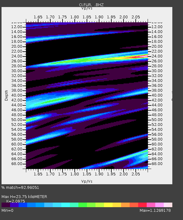
| Estimated Moho Depth: |
23.75 km |
| Estimated Crust Vp/Vs: |
2.10 |
| Assumed Crust Vp: |
6.279 km/s |
| Estimated Crust Vs: |
2.993 km/s |
| Estimated Crust Poisson's Ratio: |
0.35 |
|
| Radial Match: |
92.96051 % |
| Radial Bump: |
400 |
| Transverse Match: |
81.18496 % |
| Transverse Bump: |
400 |
| SOD ConfigId: |
414626 |
| Insert Time: |
2012-01-13 05:01:06.112 +0000 |
| GWidth: |
2.5 |
| Max Bumps: |
400 |
| Tol: |
0.001 |
|
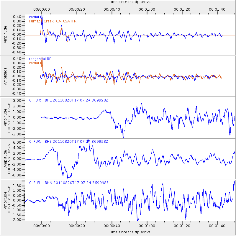
Signal To Noise
| Channel | StoN | STA | LTA |
| CI:FUR: :BHZ:20110820T17:07:24.369998Z | 15.92037 | 1.60621E-6 | 1.0089024E-7 |
| CI:FUR: :BHN:20110820T17:07:24.369998Z | 1.873749 | 2.6812563E-7 | 1.4309582E-7 |
| CI:FUR: :BHE:20110820T17:07:24.369998Z | 5.0402617 | 5.1383614E-7 | 1.0194633E-7 |
| Arrivals |
| Ps | 4.2 SECOND |
| PpPs | 12 SECOND |
| PsPs/PpSs | 16 SECOND |


