You are here: Home > Network List > CI - Caltech Regional Seismic Network Stations List
> Station HEC Hector, Baker, CA, USA > Earthquake Result Viewer
HEC Hector, Baker, CA, USA - Earthquake Result Viewer
| Earthquake location: |
Vanuatu Islands |
| Earthquake latitude/longitude: |
-18.4/168.1 |
| Earthquake time(UTC): |
2011/08/20 (232) 16:55:02 GMT |
| Earthquake Depth: |
32 km |
| Earthquake Magnitude: |
6.2 MB, 7.1 MS, 7.1 MW, 7.0 MW |
| Earthquake Catalog/Contributor: |
WHDF/NEIC |
|
| Network: |
CI Caltech Regional Seismic Network |
| Station: |
HEC Hector, Baker, CA, USA |
| Lat/Lon: |
34.83 N/116.33 W |
| Elevation: |
920 m |
|
| Distance: |
89.0 deg |
| Az: |
52.811 deg |
| Baz: |
246.879 deg |
| Ray Param: |
0.042122673 |
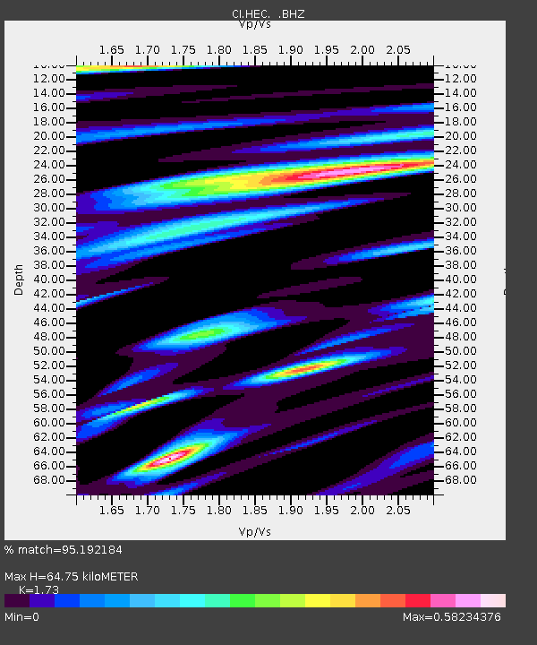
| Estimated Moho Depth: |
64.75 km |
| Estimated Crust Vp/Vs: |
1.73 |
| Assumed Crust Vp: |
6.276 km/s |
| Estimated Crust Vs: |
3.628 km/s |
| Estimated Crust Poisson's Ratio: |
0.25 |
|
| Radial Match: |
95.192184 % |
| Radial Bump: |
400 |
| Transverse Match: |
82.19582 % |
| Transverse Bump: |
400 |
| SOD ConfigId: |
414626 |
| Insert Time: |
2012-01-13 05:01:20.338 +0000 |
| GWidth: |
2.5 |
| Max Bumps: |
400 |
| Tol: |
0.001 |
|

Signal To Noise
| Channel | StoN | STA | LTA |
| CI:HEC: :BHZ:20110820T17:07:23.19501Z | 9.494845 | 1.5905794E-6 | 1.675203E-7 |
| CI:HEC: :BHN:20110820T17:07:23.19501Z | 2.1599402 | 2.8620497E-7 | 1.3250596E-7 |
| CI:HEC: :BHE:20110820T17:07:23.19501Z | 5.2093287 | 5.117334E-7 | 9.823404E-8 |
| Arrivals |
| Ps | 7.7 SECOND |
| PpPs | 28 SECOND |
| PsPs/PpSs | 35 SECOND |


