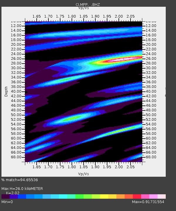
MPP McPhearson Peak - Earthquake Result Viewer
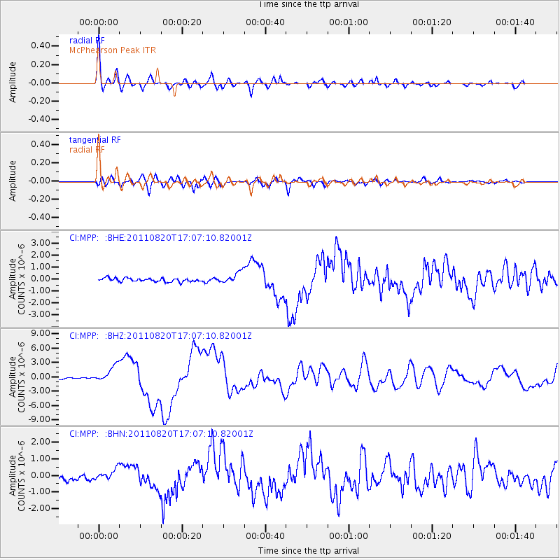
Earthquake location: Vanuatu Islands
Earthquake latitude/longitude: -18.4/168.1
Earthquake time(UTC): 2011/08/20 (232) 16:55:02 GMT
Earthquake Depth: 32 km
Earthquake Magnitude: 6.2 MB, 7.1 MS, 7.1 MW, 7.0 MW
Earthquake Catalog/Contributor: WHDF/NEIC
Network: CI Caltech Regional Seismic Network
Station: MPP McPhearson Peak
Lat/Lon: 34.89 N/119.81 W
Elevation: 1739 m
Distance: 86.4 deg
Az: 51.586 deg
Baz: 244.85 deg
Ray Param: 0.044022065
Estimated Moho Depth: 26.0 km
Estimated Crust Vp/Vs: 2.02
Assumed Crust Vp: 6.1 km/s
Estimated Crust Vs: 3.02 km/s
Estimated Crust Poisson's Ratio: 0.34
Radial Match: 94.65536 %
Radial Bump: 400
Transverse Match: 85.52368 %
Transverse Bump: 400
SOD ConfigId: 414626
Insert Time: 2012-01-13 05:02:55.398 +0000
GWidth: 2.5
Max Bumps: 400
Tol: 0.001

Signal To Noise

ChannelStoNSTALTA
CI:MPP: :BHZ:20110820T17:07:10.82001Z9.7404181.8031764E-61.851231E-7
CI:MPP: :BHN:20110820T17:07:10.82001Z1.62672033.1136352E-71.914057E-7
CI:MPP: :BHE:20110820T17:07:10.82001Z3.48512745.003895E-71.4357853E-7
Arrivals
Ps4.4 SECOND
PpPs13 SECOND
PsPs/PpSs17 SECOND