You are here: Home > Network List > G - GEOSCOPE Stations List
> Station PPTF Pamatai - Papeete - Tahiti island - French Polynesia, France > Earthquake Result Viewer
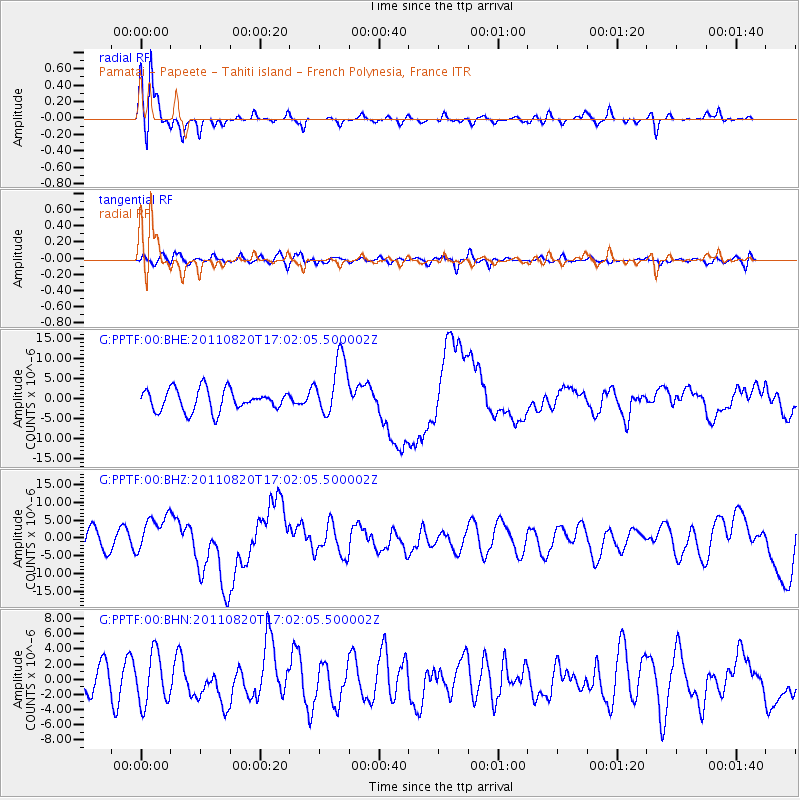
PPTF Pamatai - Papeete - Tahiti island - French Polynesia, France - Earthquake Result Viewer

| Earthquake location: |
Vanuatu Islands |
| Earthquake latitude/longitude: |
-18.4/168.1 |
| Earthquake time(UTC): |
2011/08/20 (232) 16:55:02 GMT |
| Earthquake Depth: |
32 km |
| Earthquake Magnitude: |
6.2 MB, 7.1 MS, 7.1 MW, 7.0 MW |
| Earthquake Catalog/Contributor: |
WHDF/NEIC |
|
| Network: |
G GEOSCOPE |
| Station: |
PPTF Pamatai - Papeete - Tahiti island - French Polynesia, France |
| Lat/Lon: |
17.59 S/149.57 W |
| Elevation: |
705 m |
|
| Distance: |
40.2 deg |
| Az: |
95.72 deg |
| Baz: |
262.186 deg |
| Ray Param: |
0.07449119 |
| Estimated Moho Depth: |
10.0 km |
| Estimated Crust Vp/Vs: |
1.72 |
| Assumed Crust Vp: |
4.24 km/s |
| Estimated Crust Vs: |
2.465 km/s |
| Estimated Crust Poisson's Ratio: |
0.24 |
|
| Radial Match: |
86.61932 % |
| Radial Bump: |
281 |
| Transverse Match: |
39.062035 % |
| Transverse Bump: |
400 |
| SOD ConfigId: |
414626 |
| Insert Time: |
2012-01-13 05:04:46.766 +0000 |
| GWidth: |
2.5 |
| Max Bumps: |
400 |
| Tol: |
0.001 |
|
Signal To Noise
| Channel | StoN | STA | LTA |
| G:PPTF:00:BHZ:20110820T17:02:05.500002Z | 2.8001256 | 5.366422E-6 | 1.9164934E-6 |
| G:PPTF:00:BHN:20110820T17:02:05.500002Z | 2.19283 | 3.3442523E-6 | 1.525085E-6 |
| G:PPTF:00:BHE:20110820T17:02:05.500002Z | 2.7451866 | 7.2818057E-6 | 2.6525722E-6 |
| Arrivals |
| Ps | 1.7 SECOND |
| PpPs | 6.2 SECOND |
| PsPs/PpSs | 8.0 SECOND |


