You are here: Home > Network List > IW - Intermountain West Stations List
> Station MOOW Moose Ponds, Wyoming, USA > Earthquake Result Viewer
MOOW Moose Ponds, Wyoming, USA - Earthquake Result Viewer
| Earthquake location: |
Vanuatu Islands |
| Earthquake latitude/longitude: |
-18.4/168.1 |
| Earthquake time(UTC): |
2011/08/20 (232) 16:55:02 GMT |
| Earthquake Depth: |
32 km |
| Earthquake Magnitude: |
6.2 MB, 7.1 MS, 7.1 MW, 7.0 MW |
| Earthquake Catalog/Contributor: |
WHDF/NEIC |
|
| Network: |
IW Intermountain West |
| Station: |
MOOW Moose Ponds, Wyoming, USA |
| Lat/Lon: |
43.75 N/110.74 W |
| Elevation: |
2128 m |
|
| Distance: |
96.3 deg |
| Az: |
46.081 deg |
| Baz: |
250.729 deg |
| Ray Param: |
0.04054391 |
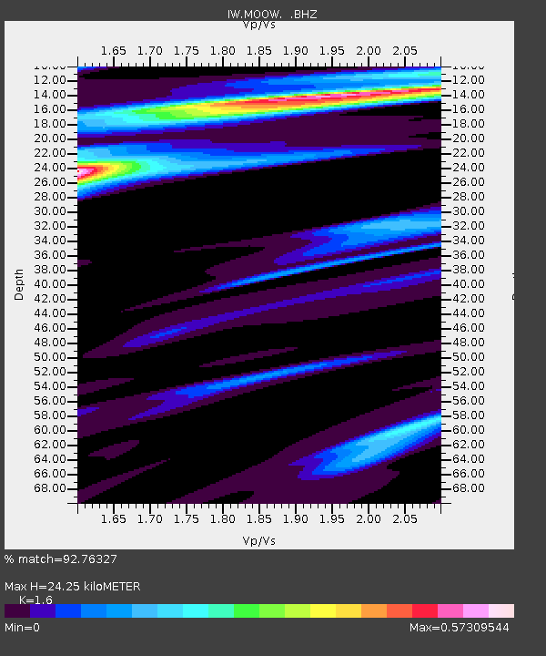
| Estimated Moho Depth: |
24.25 km |
| Estimated Crust Vp/Vs: |
1.60 |
| Assumed Crust Vp: |
6.207 km/s |
| Estimated Crust Vs: |
3.879 km/s |
| Estimated Crust Poisson's Ratio: |
0.18 |
|
| Radial Match: |
92.76327 % |
| Radial Bump: |
354 |
| Transverse Match: |
88.013054 % |
| Transverse Bump: |
400 |
| SOD ConfigId: |
414626 |
| Insert Time: |
2012-01-13 05:06:47.200 +0000 |
| GWidth: |
2.5 |
| Max Bumps: |
400 |
| Tol: |
0.001 |
|
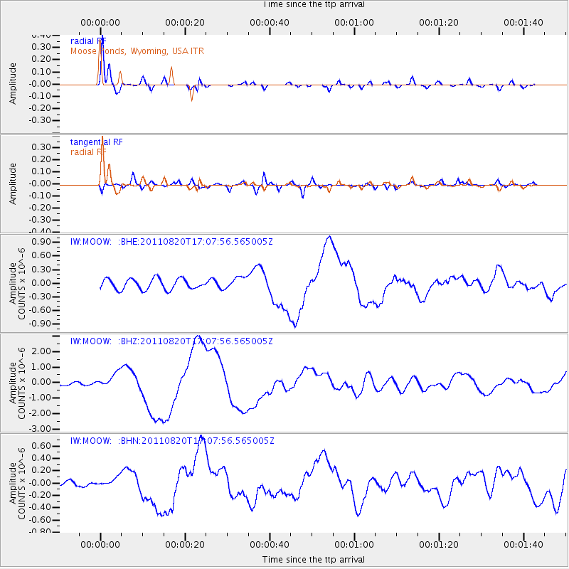
Signal To Noise
| Channel | StoN | STA | LTA |
| IW:MOOW: :BHZ:20110820T17:07:56.565005Z | 5.0456004 | 5.092458E-7 | 1.0092867E-7 |
| IW:MOOW: :BHN:20110820T17:07:56.565005Z | 1.837554 | 7.088425E-8 | 3.8575326E-8 |
| IW:MOOW: :BHE:20110820T17:07:56.565005Z | 1.152343 | 1.3441804E-7 | 1.1664759E-7 |
| Arrivals |
| Ps | 2.4 SECOND |
| PpPs | 10.0 SECOND |
| PsPs/PpSs | 12 SECOND |


