You are here: Home > Network List > IW - Intermountain West Stations List
> Station IMW Indian Meadow, Wyoming, USA > Earthquake Result Viewer
IMW Indian Meadow, Wyoming, USA - Earthquake Result Viewer
| Earthquake location: |
Vanuatu Islands |
| Earthquake latitude/longitude: |
-18.4/168.1 |
| Earthquake time(UTC): |
2011/08/20 (232) 16:55:02 GMT |
| Earthquake Depth: |
32 km |
| Earthquake Magnitude: |
6.2 MB, 7.1 MS, 7.1 MW, 7.0 MW |
| Earthquake Catalog/Contributor: |
WHDF/NEIC |
|
| Network: |
IW Intermountain West |
| Station: |
IMW Indian Meadow, Wyoming, USA |
| Lat/Lon: |
43.90 N/110.94 W |
| Elevation: |
2646 m |
|
| Distance: |
96.2 deg |
| Az: |
45.893 deg |
| Baz: |
250.615 deg |
| Ray Param: |
0.040566124 |
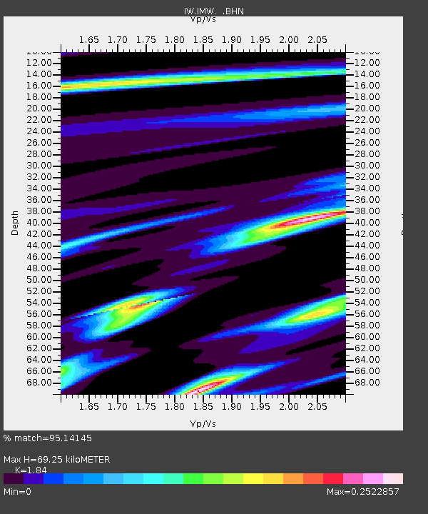
| Estimated Moho Depth: |
69.25 km |
| Estimated Crust Vp/Vs: |
1.84 |
| Assumed Crust Vp: |
6.207 km/s |
| Estimated Crust Vs: |
3.373 km/s |
| Estimated Crust Poisson's Ratio: |
0.29 |
|
| Radial Match: |
95.14145 % |
| Radial Bump: |
336 |
| Transverse Match: |
86.39909 % |
| Transverse Bump: |
400 |
| SOD ConfigId: |
414626 |
| Insert Time: |
2012-01-13 05:07:00.672 +0000 |
| GWidth: |
2.5 |
| Max Bumps: |
400 |
| Tol: |
0.001 |
|

Signal To Noise
| Channel | StoN | STA | LTA |
| IW:IMW: :BHZ:20110820T17:07:56.17499Z | 6.8963814 | 4.62415E-7 | 6.705183E-8 |
| IW:IMW: :BHN:20110820T17:07:56.17499Z | 0.7523867 | 5.565753E-8 | 7.397463E-8 |
| IW:IMW: :BHE:20110820T17:07:56.17499Z | 2.1797993 | 1.7752316E-7 | 8.144014E-8 |
| Arrivals |
| Ps | 9.5 SECOND |
| PpPs | 31 SECOND |
| PsPs/PpSs | 41 SECOND |


