You are here: Home > Network List > TA - USArray Transportable Network (new EarthScope stations) Stations List
> Station G03D McMinnville, OR, USA > Earthquake Result Viewer
G03D McMinnville, OR, USA - Earthquake Result Viewer
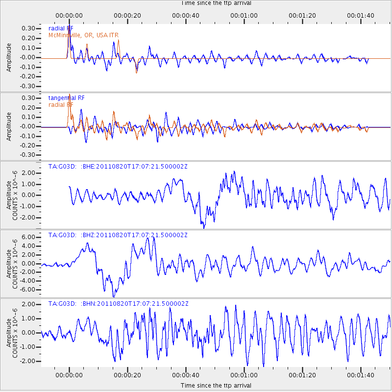
| Earthquake location: |
Vanuatu Islands |
| Earthquake latitude/longitude: |
-18.4/168.1 |
| Earthquake time(UTC): |
2011/08/20 (232) 16:55:02 GMT |
| Earthquake Depth: |
32 km |
| Earthquake Magnitude: |
6.2 MB, 7.1 MS, 7.1 MW, 7.0 MW |
| Earthquake Catalog/Contributor: |
WHDF/NEIC |
|
| Network: |
TA USArray Transportable Network (new EarthScope stations) |
| Station: |
G03D McMinnville, OR, USA |
| Lat/Lon: |
45.21 N/123.26 W |
| Elevation: |
222 m |
|
| Distance: |
88.7 deg |
| Az: |
41.169 deg |
| Baz: |
242.181 deg |
| Ray Param: |
0.042385966 |
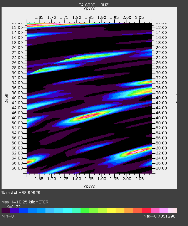
| Estimated Moho Depth: |
10.25 km |
| Estimated Crust Vp/Vs: |
1.72 |
| Assumed Crust Vp: |
6.566 km/s |
| Estimated Crust Vs: |
3.818 km/s |
| Estimated Crust Poisson's Ratio: |
0.24 |
|
| Radial Match: |
88.90929 % |
| Radial Bump: |
400 |
| Transverse Match: |
81.74034 % |
| Transverse Bump: |
400 |
| SOD ConfigId: |
414626 |
| Insert Time: |
2012-01-13 05:10:11.357 +0000 |
| GWidth: |
2.5 |
| Max Bumps: |
400 |
| Tol: |
0.001 |
|
Signal To Noise
| Channel | StoN | STA | LTA |
| TA:G03D: :BHZ:20110820T17:07:21.500002Z | 6.2916474 | 1.7654521E-6 | 2.806025E-7 |
| TA:G03D: :BHN:20110820T17:07:21.500002Z | 2.6160753 | 4.636307E-7 | 1.7722377E-7 |
| TA:G03D: :BHE:20110820T17:07:21.500002Z | 1.6925037 | 5.994677E-7 | 3.541899E-7 |
| Arrivals |
| Ps | 1.2 SECOND |
| PpPs | 4.1 SECOND |
| PsPs/PpSs | 5.3 SECOND |


