You are here: Home > Network List > TA - USArray Transportable Network (new EarthScope stations) Stations List
> Station N02D Trinity Center, CA, USA > Earthquake Result Viewer
N02D Trinity Center, CA, USA - Earthquake Result Viewer
| Earthquake location: |
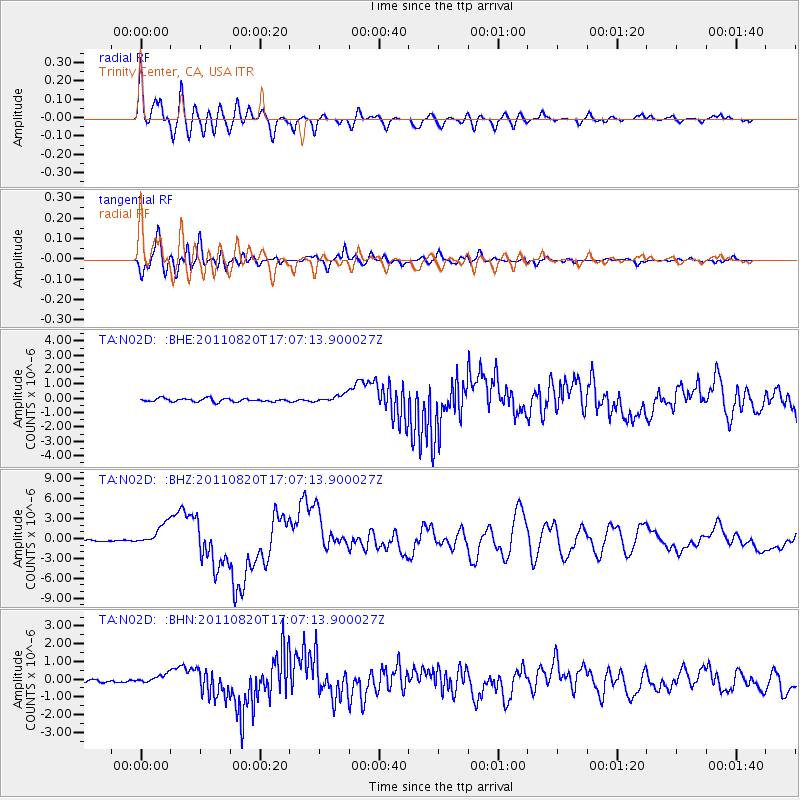
Vanuatu Islands |
| Earthquake latitude/longitude: |
-18.4/168.1 |
| Earthquake time(UTC): |
2011/08/20 (232) 16:55:02 GMT |
| Earthquake Depth: |
32 km |
| Earthquake Magnitude: |
6.2 MB, 7.1 MS, 7.1 MW, 7.0 MW |
| Earthquake Catalog/Contributor: |
WHDF/NEIC |
|
| Network: |
TA USArray Transportable Network (new EarthScope stations) |
| Station: |
N02D Trinity Center, CA, USA |
| Lat/Lon: |
40.97 N/122.71 W |
| Elevation: |
937 m |
|
| Distance: |
87.1 deg |
| Az: |
45.117 deg |
| Baz: |
242.709 deg |
| Ray Param: |
0.04355926 |
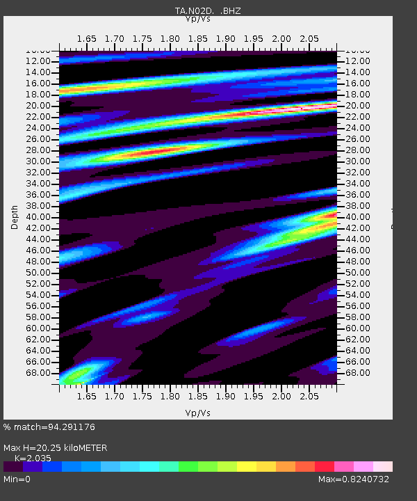
| Estimated Moho Depth: |
20.25 km |
| Estimated Crust Vp/Vs: |
2.04 |
| Assumed Crust Vp: |
6.566 km/s |
| Estimated Crust Vs: |
3.227 km/s |
| Estimated Crust Poisson's Ratio: |
0.34 |
|
| Radial Match: |
94.291176 % |
| Radial Bump: |
400 |
| Transverse Match: |
92.08864 % |
| Transverse Bump: |
400 |
| SOD ConfigId: |
414626 |
| Insert Time: |
2012-01-13 05:10:24.381 +0000 |
| GWidth: |
2.5 |
| Max Bumps: |
400 |
| Tol: |
0.001 |
|
Signal To Noise
| Channel | StoN | STA | LTA |
| TA:N02D: :BHZ:20110820T17:07:13.900027Z | 13.9876375 | 1.6252931E-6 | 1.1619497E-7 |
| TA:N02D: :BHN:20110820T17:07:13.900027Z | 1.8886876 | 2.4371997E-7 | 1.2904196E-7 |
| TA:N02D: :BHE:20110820T17:07:13.900027Z | 2.4772737 | 2.8438237E-7 | 1.1479651E-7 |
| Arrivals |
| Ps | 3.3 SECOND |
| PpPs | 9.2 SECOND |
| PsPs/PpSs | 12 SECOND |


