You are here: Home > Network List > TA - USArray Transportable Network (new EarthScope stations) Stations List
> Station I02D Swisshome, OR, USA > Earthquake Result Viewer
I02D Swisshome, OR, USA - Earthquake Result Viewer
| Earthquake location: |
Vanuatu Islands |
| Earthquake latitude/longitude: |
-18.4/168.1 |
| Earthquake time(UTC): |
2011/08/20 (232) 16:55:02 GMT |
| Earthquake Depth: |
32 km |
| Earthquake Magnitude: |
6.2 MB, 7.1 MS, 7.1 MW, 7.0 MW |
| Earthquake Catalog/Contributor: |
WHDF/NEIC |
|
| Network: |
TA USArray Transportable Network (new EarthScope stations) |
| Station: |
I02D Swisshome, OR, USA |
| Lat/Lon: |
44.11 N/123.85 W |
| Elevation: |
109 m |
|
| Distance: |
87.8 deg |
| Az: |
41.95 deg |
| Baz: |
241.797 deg |
| Ray Param: |
0.043044813 |
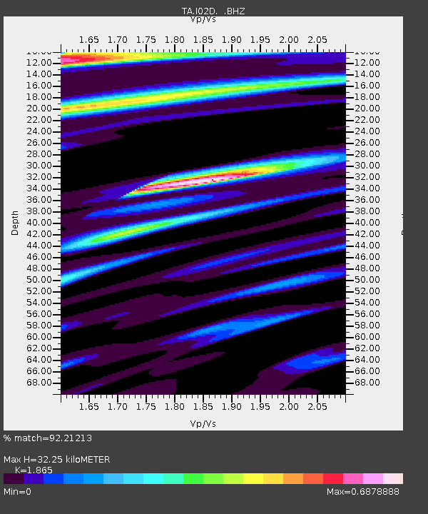
| Estimated Moho Depth: |
32.25 km |
| Estimated Crust Vp/Vs: |
1.87 |
| Assumed Crust Vp: |
6.566 km/s |
| Estimated Crust Vs: |
3.521 km/s |
| Estimated Crust Poisson's Ratio: |
0.30 |
|
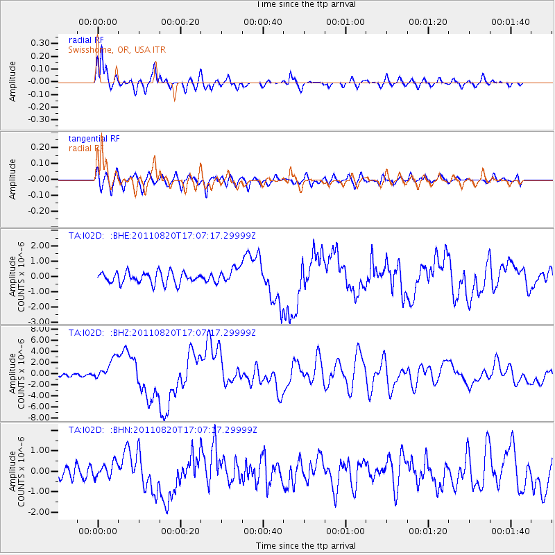
| Radial Match: |
92.21213 % |
| Radial Bump: |
400 |
| Transverse Match: |
76.20958 % |
| Transverse Bump: |
400 |
| SOD ConfigId: |
414626 |
| Insert Time: |
2012-01-13 05:11:04.746 +0000 |
| GWidth: |
2.5 |
| Max Bumps: |
400 |
| Tol: |
0.001 |
|
Signal To Noise
| Channel | StoN | STA | LTA |
| TA:I02D: :BHZ:20110820T17:07:17.29999Z | 8.3887615 | 1.9964857E-6 | 2.379953E-7 |
| TA:I02D: :BHN:20110820T17:07:17.29999Z | 1.5483007 | 3.6688664E-7 | 2.3696083E-7 |
| TA:I02D: :BHE:20110820T17:07:17.29999Z | 1.3763107 | 5.0013057E-7 | 3.633849E-7 |
| Arrivals |
| Ps | 4.3 SECOND |
| PpPs | 14 SECOND |
| PsPs/PpSs | 18 SECOND |


