You are here: Home > Network List > TA - USArray Transportable Network (new EarthScope stations) Stations List
> Station TOLK Tollok Lake Research Station, AK, USA > Earthquake Result Viewer
TOLK Tollok Lake Research Station, AK, USA - Earthquake Result Viewer

| Earthquake location: |
Vanuatu Islands |
| Earthquake latitude/longitude: |
-18.4/168.1 |
| Earthquake time(UTC): |
2011/08/20 (232) 16:55:02 GMT |
| Earthquake Depth: |
32 km |
| Earthquake Magnitude: |
6.2 MB, 7.1 MS, 7.1 MW, 7.0 MW |
| Earthquake Catalog/Contributor: |
WHDF/NEIC |
|
| Network: |
TA USArray Transportable Network (new EarthScope stations) |
| Station: |
TOLK Tollok Lake Research Station, AK, USA |
| Lat/Lon: |
68.64 N/149.57 W |
| Elevation: |
760 m |
|
| Distance: |
91.9 deg |
| Az: |
14.278 deg |
| Baz: |
219.743 deg |
| Ray Param: |
0.041524295 |
| Estimated Moho Depth: |
43.25 km |
| Estimated Crust Vp/Vs: |
1.79 |
| Assumed Crust Vp: |
6.316 km/s |
| Estimated Crust Vs: |
3.538 km/s |
| Estimated Crust Poisson's Ratio: |
0.27 |
|
| Radial Match: |
95.17687 % |
| Radial Bump: |
400 |
| Transverse Match: |
91.80369 % |
| Transverse Bump: |
400 |
| SOD ConfigId: |
414626 |
| Insert Time: |
2012-01-13 05:11:58.252 +0000 |
| GWidth: |
2.5 |
| Max Bumps: |
400 |
| Tol: |
0.001 |
|
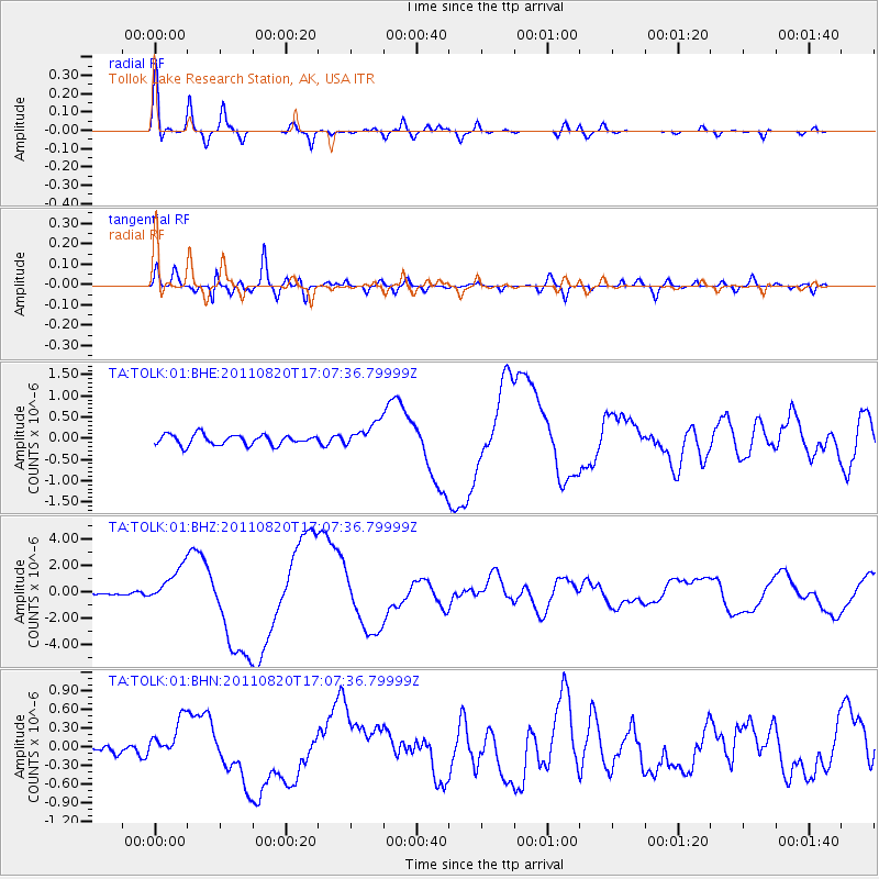
Signal To Noise
| Channel | StoN | STA | LTA |
| TA:TOLK:01:BHZ:20110820T17:07:36.79999Z | 11.900467 | 1.3847996E-6 | 1.1636515E-7 |
| TA:TOLK:01:BHN:20110820T17:07:36.79999Z | 3.7591124 | 3.2219833E-7 | 8.5711285E-8 |
| TA:TOLK:01:BHE:20110820T17:07:36.79999Z | 2.382058 | 2.9067027E-7 | 1.2202486E-7 |
| Arrivals |
| Ps | 5.5 SECOND |
| PpPs | 19 SECOND |
| PsPs/PpSs | 24 SECOND |


