You are here: Home > Network List > UW - Pacific Northwest Regional Seismic Network Stations List
> Station TAKO Tahkenitch, OR CREST BB SMO > Earthquake Result Viewer
TAKO Tahkenitch, OR CREST BB SMO - Earthquake Result Viewer

| Earthquake location: |
Vanuatu Islands |
| Earthquake latitude/longitude: |
-18.4/168.1 |
| Earthquake time(UTC): |
2011/08/20 (232) 16:55:02 GMT |
| Earthquake Depth: |
32 km |
| Earthquake Magnitude: |
6.2 MB, 7.1 MS, 7.1 MW, 7.0 MW |
| Earthquake Catalog/Contributor: |
WHDF/NEIC |
|
| Network: |
UW Pacific Northwest Regional Seismic Network |
| Station: |
TAKO Tahkenitch, OR CREST BB SMO |
| Lat/Lon: |
43.74 N/124.08 W |
| Elevation: |
46 m |
|
| Distance: |
87.4 deg |
| Az: |
42.189 deg |
| Baz: |
241.644 deg |
| Ray Param: |
0.0432818 |
| Estimated Moho Depth: |
10.75 km |
| Estimated Crust Vp/Vs: |
1.86 |
| Assumed Crust Vp: |
6.048 km/s |
| Estimated Crust Vs: |
3.247 km/s |
| Estimated Crust Poisson's Ratio: |
0.30 |
|
| Radial Match: |
90.22691 % |
| Radial Bump: |
400 |
| Transverse Match: |
66.99839 % |
| Transverse Bump: |
400 |
| SOD ConfigId: |
414626 |
| Insert Time: |
2012-01-13 05:13:25.769 +0000 |
| GWidth: |
2.5 |
| Max Bumps: |
400 |
| Tol: |
0.001 |
|
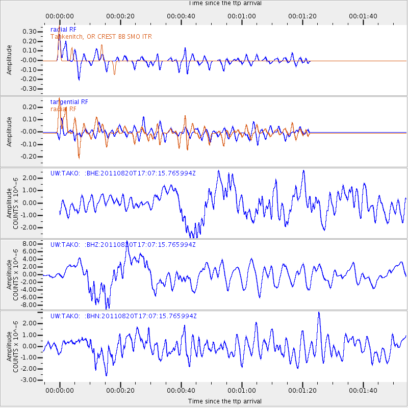
Signal To Noise
| Channel | StoN | STA | LTA |
| UW:TAKO: :BHZ:20110820T17:07:15.765994Z | 4.125269 | 1.723041E-6 | 4.1767967E-7 |
| UW:TAKO: :BHN:20110820T17:07:15.765994Z | 1.1923084 | 4.6483095E-7 | 3.8985797E-7 |
| UW:TAKO: :BHE:20110820T17:07:15.765994Z | 1.5367014 | 7.288503E-7 | 4.7429532E-7 |
| Arrivals |
| Ps | 1.6 SECOND |
| PpPs | 5.0 SECOND |
| PsPs/PpSs | 6.6 SECOND |


