You are here: Home > Network List > UW - Pacific Northwest Regional Seismic Network Stations List
> Station OMAK Colville Reservation, Omak, WA, USA > Earthquake Result Viewer
OMAK Colville Reservation, Omak, WA, USA - Earthquake Result Viewer
| Earthquake location: |
Vanuatu Islands |
| Earthquake latitude/longitude: |
-18.4/168.1 |
| Earthquake time(UTC): |
2011/08/20 (232) 16:55:02 GMT |
| Earthquake Depth: |
32 km |
| Earthquake Magnitude: |
6.2 MB, 7.1 MS, 7.1 MW, 7.0 MW |
| Earthquake Catalog/Contributor: |
WHDF/NEIC |
|
| Network: |
UW Pacific Northwest Regional Seismic Network |
| Station: |
OMAK Colville Reservation, Omak, WA, USA |
| Lat/Lon: |
48.36 N/119.33 W |
| Elevation: |
696 m |
|
| Distance: |
92.5 deg |
| Az: |
39.551 deg |
| Baz: |
245.054 deg |
| Ray Param: |
0.04144143 |
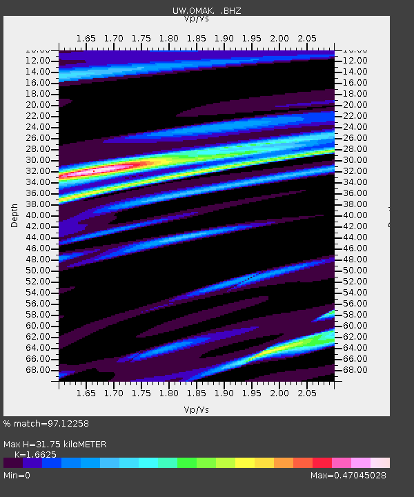
| Estimated Moho Depth: |
31.75 km |
| Estimated Crust Vp/Vs: |
1.66 |
| Assumed Crust Vp: |
6.419 km/s |
| Estimated Crust Vs: |
3.861 km/s |
| Estimated Crust Poisson's Ratio: |
0.22 |
|
| Radial Match: |
97.12258 % |
| Radial Bump: |
400 |
| Transverse Match: |
77.21811 % |
| Transverse Bump: |
400 |
| SOD ConfigId: |
414626 |
| Insert Time: |
2012-01-13 05:13:56.779 +0000 |
| GWidth: |
2.5 |
| Max Bumps: |
400 |
| Tol: |
0.001 |
|
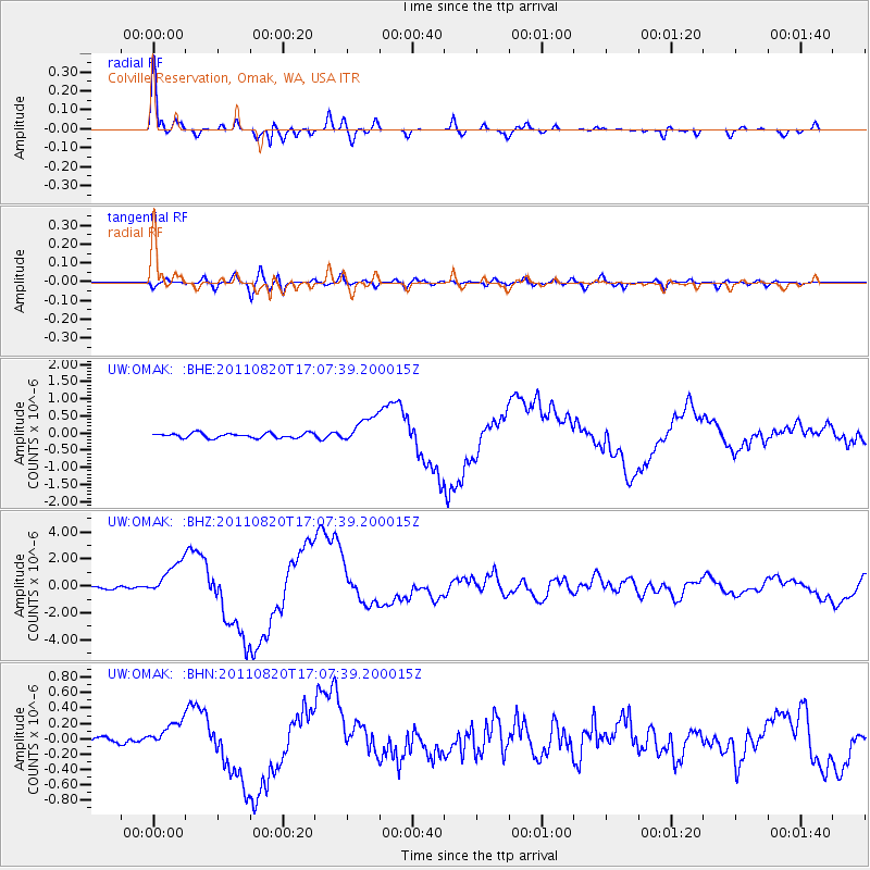
Signal To Noise
| Channel | StoN | STA | LTA |
| UW:OMAK: :BHZ:20110820T17:07:39.200015Z | 14.858242 | 1.2703024E-6 | 8.54948E-8 |
| UW:OMAK: :BHN:20110820T17:07:39.200015Z | 4.1898017 | 1.6316704E-7 | 3.8943863E-8 |
| UW:OMAK: :BHE:20110820T17:07:39.200015Z | 5.485748 | 3.8971504E-7 | 7.104137E-8 |
| Arrivals |
| Ps | 3.3 SECOND |
| PpPs | 13 SECOND |
| PsPs/PpSs | 16 SECOND |


