You are here: Home > Network List > TA - USArray Transportable Network (new EarthScope stations) Stations List
> Station J04D Umpqua National Forest, Toketee, OR, USA > Earthquake Result Viewer
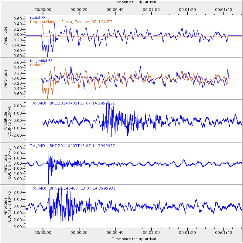
J04D Umpqua National Forest, Toketee, OR, USA - Earthquake Result Viewer
*The percent match for this event was below the threshold and hence no stack was calculated.
| Earthquake location: |
Fiji Islands Region |
| Earthquake latitude/longitude: |
-18.0/-178.4 |
| Earthquake time(UTC): |
2014/04/03 (093) 12:56:36 GMT |
| Earthquake Depth: |
579 km |
| Earthquake Magnitude: |
5.3 mb |
| Earthquake Catalog/Contributor: |
ISC/ISC |
|
| Network: |
TA USArray Transportable Network (new EarthScope stations) |
| Station: |
J04D Umpqua National Forest, Toketee, OR, USA |
| Lat/Lon: |
43.24 N/122.11 W |
| Elevation: |
1948 m |
|
| Distance: |
79.8 deg |
| Az: |
38.116 deg |
| Baz: |
233.484 deg |
| Ray Param: |
$rayparam |
*The percent match for this event was below the threshold and hence was not used in the summary stack. |
|
| Radial Match: |
57.57044 % |
| Radial Bump: |
400 |
| Transverse Match: |
52.821293 % |
| Transverse Bump: |
400 |
| SOD ConfigId: |
3390531 |
| Insert Time: |
2019-04-11 03:27:36.148 +0000 |
| GWidth: |
2.5 |
| Max Bumps: |
400 |
| Tol: |
0.001 |
|
Signal To Noise
| Channel | StoN | STA | LTA |
| TA:J04D: :BHZ:20140403T13:07:14.399993Z | 5.3583603 | 1.0290034E-6 | 1.9203699E-7 |
| TA:J04D: :BHN:20140403T13:07:14.399993Z | 3.0099244 | 7.868537E-7 | 2.6141976E-7 |
| TA:J04D: :BHE:20140403T13:07:14.399993Z | 1.8502953 | 5.274757E-7 | 2.850765E-7 |
| Arrivals |
| Ps | |
| PpPs | |
| PsPs/PpSs | |


