You are here: Home > Network List > BK - Berkeley Digital Seismograph Network Stations List
> Station HUMO Hull Mountain, OR > Earthquake Result Viewer
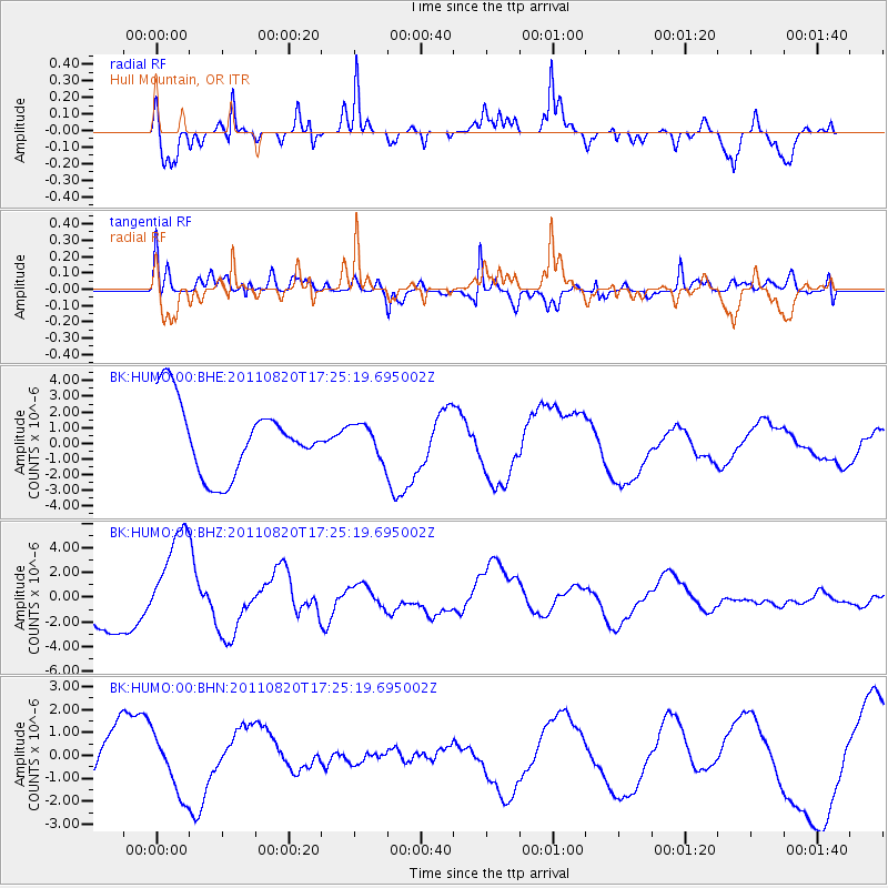
HUMO Hull Mountain, OR - Earthquake Result Viewer
*The percent match for this event was below the threshold and hence no stack was calculated.
| Earthquake location: |
Vanuatu Islands |
| Earthquake latitude/longitude: |
-18.3/168.2 |
| Earthquake time(UTC): |
2011/08/20 (232) 17:13:06 GMT |
| Earthquake Depth: |
35 km |
| Earthquake Magnitude: |
5.9 MB, 6.5 MW |
| Earthquake Catalog/Contributor: |
WHDF/NEIC |
|
| Network: |
BK Berkeley Digital Seismograph Network |
| Station: |
HUMO Hull Mountain, OR |
| Lat/Lon: |
42.61 N/122.96 W |
| Elevation: |
555 m |
|
| Distance: |
87.6 deg |
| Az: |
43.577 deg |
| Baz: |
242.501 deg |
| Ray Param: |
$rayparam |
*The percent match for this event was below the threshold and hence was not used in the summary stack. |
|
| Radial Match: |
63.44391 % |
| Radial Bump: |
308 |
| Transverse Match: |
62.007275 % |
| Transverse Bump: |
400 |
| SOD ConfigId: |
414626 |
| Insert Time: |
2012-01-13 05:19:22.684 +0000 |
| GWidth: |
2.5 |
| Max Bumps: |
400 |
| Tol: |
0.001 |
|
Signal To Noise
| Channel | StoN | STA | LTA |
| BK:HUMO:00:BHZ:20110820T17:25:19.695002Z | 3.0468524 | 4.1295475E-6 | 1.3553487E-6 |
| BK:HUMO:00:BHN:20110820T17:25:19.695002Z | 0.7604562 | 1.4147018E-6 | 1.8603331E-6 |
| BK:HUMO:00:BHE:20110820T17:25:19.695002Z | 0.47410893 | 1.0598799E-6 | 2.2355198E-6 |
| Arrivals |
| Ps | |
| PpPs | |
| PsPs/PpSs | |


