You are here: Home > Network List > TA - USArray Transportable Network (new EarthScope stations) Stations List
> Station J04D Umpqua National Forest, Toketee, OR, USA > Earthquake Result Viewer
J04D Umpqua National Forest, Toketee, OR, USA - Earthquake Result Viewer

| Earthquake location: |
Vanuatu Islands |
| Earthquake latitude/longitude: |
-18.3/168.2 |
| Earthquake time(UTC): |
2011/08/20 (232) 18:19:23 GMT |
| Earthquake Depth: |
28 km |
| Earthquake Magnitude: |
6.4 MB, 7.1 MS, 7.1 MW, 7.0 MW |
| Earthquake Catalog/Contributor: |
WHDF/NEIC |
|
| Network: |
TA USArray Transportable Network (new EarthScope stations) |
| Station: |
J04D Umpqua National Forest, Toketee, OR, USA |
| Lat/Lon: |
43.24 N/122.11 W |
| Elevation: |
1948 m |
|
| Distance: |
88.4 deg |
| Az: |
43.278 deg |
| Baz: |
243.022 deg |
| Ray Param: |
0.042585455 |
| Estimated Moho Depth: |
62.75 km |
| Estimated Crust Vp/Vs: |
1.64 |
| Assumed Crust Vp: |
6.522 km/s |
| Estimated Crust Vs: |
3.971 km/s |
| Estimated Crust Poisson's Ratio: |
0.21 |
|
| Radial Match: |
84.00562 % |
| Radial Bump: |
400 |
| Transverse Match: |
80.44187 % |
| Transverse Bump: |
400 |
| SOD ConfigId: |
414626 |
| Insert Time: |
2012-01-13 05:33:00.656 +0000 |
| GWidth: |
2.5 |
| Max Bumps: |
400 |
| Tol: |
0.001 |
|
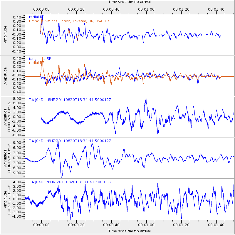
Signal To Noise
| Channel | StoN | STA | LTA |
| TA:J04D: :BHZ:20110820T18:31:41.500012Z | 4.4396214 | 2.953393E-6 | 6.652353E-7 |
| TA:J04D: :BHN:20110820T18:31:41.500012Z | 1.3338811 | 9.187495E-7 | 6.8877915E-7 |
| TA:J04D: :BHE:20110820T18:31:41.500012Z | 1.2585256 | 2.1855524E-6 | 1.7365974E-6 |
| Arrivals |
| Ps | 6.3 SECOND |
| PpPs | 25 SECOND |
| PsPs/PpSs | 31 SECOND |


