You are here: Home > Network List > TA - USArray Transportable Network (new EarthScope stations) Stations List
> Station F04D Rainier, OR, USA > Earthquake Result Viewer
F04D Rainier, OR, USA - Earthquake Result Viewer
| Earthquake location: |
Vanuatu Islands |
| Earthquake latitude/longitude: |
-18.3/168.2 |
| Earthquake time(UTC): |
2011/08/20 (232) 18:19:23 GMT |
| Earthquake Depth: |
28 km |
| Earthquake Magnitude: |
6.4 MB, 7.1 MS, 7.1 MW, 7.0 MW |
| Earthquake Catalog/Contributor: |
WHDF/NEIC |
|
| Network: |
TA USArray Transportable Network (new EarthScope stations) |
| Station: |
F04D Rainier, OR, USA |
| Lat/Lon: |
46.08 N/123.01 W |
| Elevation: |
236 m |
|
| Distance: |
89.1 deg |
| Az: |
40.457 deg |
| Baz: |
242.329 deg |
| Ray Param: |
0.04204395 |
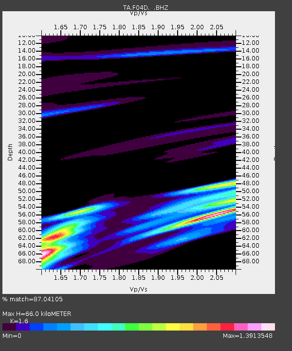
| Estimated Moho Depth: |
66.0 km |
| Estimated Crust Vp/Vs: |
1.60 |
| Assumed Crust Vp: |
6.566 km/s |
| Estimated Crust Vs: |
4.104 km/s |
| Estimated Crust Poisson's Ratio: |
0.18 |
|
| Radial Match: |
87.04105 % |
| Radial Bump: |
367 |
| Transverse Match: |
80.1057 % |
| Transverse Bump: |
400 |
| SOD ConfigId: |
414626 |
| Insert Time: |
2012-01-13 05:33:26.529 +0000 |
| GWidth: |
2.5 |
| Max Bumps: |
400 |
| Tol: |
0.001 |
|

Signal To Noise
| Channel | StoN | STA | LTA |
| TA:F04D: :BHZ:20110820T18:31:44.950024Z | 3.6450112 | 3.4988802E-6 | 9.599094E-7 |
| TA:F04D: :BHN:20110820T18:31:44.950024Z | 0.55664444 | 8.3808084E-7 | 1.5055945E-6 |
| TA:F04D: :BHE:20110820T18:31:44.950024Z | 0.91217023 | 8.26771E-7 | 9.063779E-7 |
| Arrivals |
| Ps | 6.2 SECOND |
| PpPs | 26 SECOND |
| PsPs/PpSs | 32 SECOND |


