You are here: Home > Network List > UW - Pacific Northwest Regional Seismic Network Stations List
> Station FISH Seaside, OR, USA > Earthquake Result Viewer
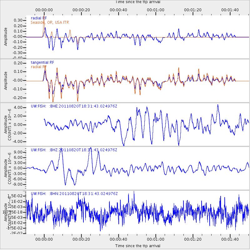
FISH Seaside, OR, USA - Earthquake Result Viewer
*The percent match for this event was below the threshold and hence no stack was calculated.
| Earthquake location: |
Vanuatu Islands |
| Earthquake latitude/longitude: |
-18.3/168.2 |
| Earthquake time(UTC): |
2011/08/20 (232) 18:19:23 GMT |
| Earthquake Depth: |
28 km |
| Earthquake Magnitude: |
6.4 MB, 7.1 MS, 7.1 MW, 7.0 MW |
| Earthquake Catalog/Contributor: |
WHDF/NEIC |
|
| Network: |
UW Pacific Northwest Regional Seismic Network |
| Station: |
FISH Seaside, OR, USA |
| Lat/Lon: |
45.93 N/123.56 W |
| Elevation: |
325 m |
|
| Distance: |
88.7 deg |
| Az: |
40.413 deg |
| Baz: |
241.935 deg |
| Ray Param: |
$rayparam |
*The percent match for this event was below the threshold and hence was not used in the summary stack. |
|
| Radial Match: |
82.94666 % |
| Radial Bump: |
400 |
| Transverse Match: |
82.906 % |
| Transverse Bump: |
400 |
| SOD ConfigId: |
414626 |
| Insert Time: |
2012-01-13 05:34:41.730 +0000 |
| GWidth: |
2.5 |
| Max Bumps: |
400 |
| Tol: |
0.001 |
|
Signal To Noise
| Channel | StoN | STA | LTA |
| UW:FISH: :BHZ:20110820T18:31:43.024976Z | 1.8112184 | 2.3765049E-6 | 1.3121029E-6 |
| UW:FISH: :BHN:20110820T18:31:43.024976Z | 0.81091213 | 4.906779E-9 | 6.0509384E-9 |
| UW:FISH: :BHE:20110820T18:31:43.024976Z | 1.5438755 | 1.0477814E-6 | 6.7866966E-7 |
| Arrivals |
| Ps | |
| PpPs | |
| PsPs/PpSs | |


