You are here: Home > Network List > GT - Global Telemetered Seismograph Network (USAF/USGS) Stations List
> Station LPAZ La Paz , Bolivia > Earthquake Result Viewer
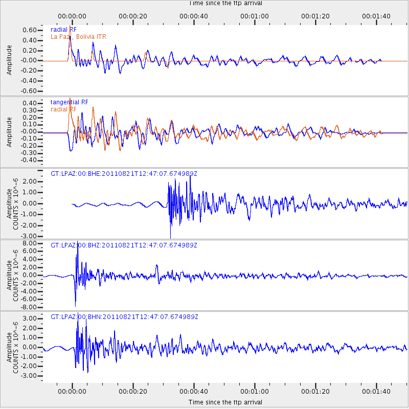
LPAZ La Paz , Bolivia - Earthquake Result Viewer
*The percent match for this event was below the threshold and hence no stack was calculated.
| Earthquake location: |
South Sandwich Islands Region |
| Earthquake latitude/longitude: |
-56.4/-27.5 |
| Earthquake time(UTC): |
2011/08/21 (233) 12:38:53 GMT |
| Earthquake Depth: |
130 km |
| Earthquake Magnitude: |
5.6 MB, 5.6 MW |
| Earthquake Catalog/Contributor: |
WHDF/NEIC |
|
| Network: |
GT Global Telemetered Seismograph Network (USAF/USGS) |
| Station: |
LPAZ La Paz , Bolivia |
| Lat/Lon: |
16.17 S/68.08 W |
| Elevation: |
4817 m |
|
| Distance: |
50.5 deg |
| Az: |
305.928 deg |
| Baz: |
152.085 deg |
| Ray Param: |
$rayparam |
*The percent match for this event was below the threshold and hence was not used in the summary stack. |
|
| Radial Match: |
78.354805 % |
| Radial Bump: |
400 |
| Transverse Match: |
59.266495 % |
| Transverse Bump: |
400 |
| SOD ConfigId: |
414626 |
| Insert Time: |
2012-01-13 05:40:06.749 +0000 |
| GWidth: |
2.5 |
| Max Bumps: |
400 |
| Tol: |
0.001 |
|
Signal To Noise
| Channel | StoN | STA | LTA |
| GT:LPAZ:00:BHZ:20110821T12:47:07.674989Z | 21.841825 | 2.4697042E-6 | 1.1307225E-7 |
| GT:LPAZ:00:BHN:20110821T12:47:07.674989Z | 7.2569604 | 1.1532031E-6 | 1.5890994E-7 |
| GT:LPAZ:00:BHE:20110821T12:47:07.674989Z | 9.283386 | 9.879664E-7 | 1.0642306E-7 |
| Arrivals |
| Ps | |
| PpPs | |
| PsPs/PpSs | |


