You are here: Home > Network List > TA - USArray Transportable Network (new EarthScope stations) Stations List
> Station J05D Fort Rock, OR, USA > Earthquake Result Viewer
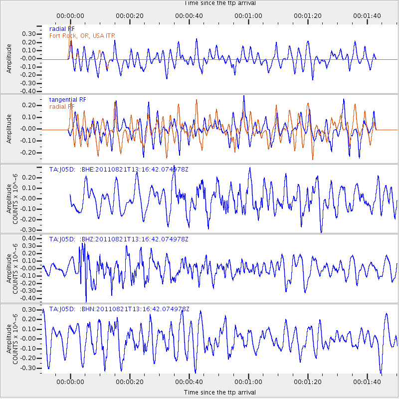
J05D Fort Rock, OR, USA - Earthquake Result Viewer
*The percent match for this event was below the threshold and hence no stack was calculated.
| Earthquake location: |
New Britain Region, P.N.G. |
| Earthquake latitude/longitude: |
-5.6/151.0 |
| Earthquake time(UTC): |
2011/08/21 (233) 13:04:08 GMT |
| Earthquake Depth: |
40 km |
| Earthquake Magnitude: |
5.5 MS, 5.4 MB, 5.8 MW, 5.8 MW |
| Earthquake Catalog/Contributor: |
WHDF/NEIC |
|
| Network: |
TA USArray Transportable Network (new EarthScope stations) |
| Station: |
J05D Fort Rock, OR, USA |
| Lat/Lon: |
43.28 N/121.23 W |
| Elevation: |
1541 m |
|
| Distance: |
92.1 deg |
| Az: |
46.902 deg |
| Baz: |
264.418 deg |
| Ray Param: |
$rayparam |
*The percent match for this event was below the threshold and hence was not used in the summary stack. |
|
| Radial Match: |
47.791653 % |
| Radial Bump: |
400 |
| Transverse Match: |
40.74641 % |
| Transverse Bump: |
340 |
| SOD ConfigId: |
414626 |
| Insert Time: |
2012-01-13 05:47:40.408 +0000 |
| GWidth: |
2.5 |
| Max Bumps: |
400 |
| Tol: |
0.001 |
|
Signal To Noise
| Channel | StoN | STA | LTA |
| TA:J05D: :BHZ:20110821T13:16:42.074978Z | 2.4510396 | 1.6230487E-7 | 6.6218796E-8 |
| TA:J05D: :BHN:20110821T13:16:42.074978Z | 1.1903019 | 1.4734673E-7 | 1.2378938E-7 |
| TA:J05D: :BHE:20110821T13:16:42.074978Z | 1.2480953 | 1.362116E-7 | 1.0913558E-7 |
| Arrivals |
| Ps | |
| PpPs | |
| PsPs/PpSs | |


