You are here: Home > Network List > G - GEOSCOPE Stations List
> Station DRV Dumont d'Urville, Terre Adelie (Antartica) > Earthquake Result Viewer
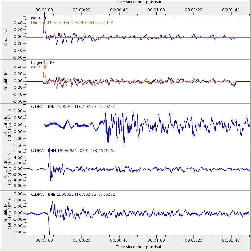
DRV Dumont d'Urville, Terre Adelie (Antartica) - Earthquake Result Viewer
*The percent match for this event was below the threshold and hence no stack was calculated.
| Earthquake location: |
Minahassa Peninsula, Sulawesi |
| Earthquake latitude/longitude: |
0.3/122.5 |
| Earthquake time(UTC): |
1998/09/21 (264) 06:52:41 GMT |
| Earthquake Depth: |
147 km |
| Earthquake Magnitude: |
6.1 MB, 6.0 UNKNOWN, 5.9 MW |
| Earthquake Catalog/Contributor: |
WHDF/NEIC |
|
| Network: |
G GEOSCOPE |
| Station: |
DRV Dumont d'Urville, Terre Adelie (Antartica) |
| Lat/Lon: |
66.67 S/140.01 E |
| Elevation: |
40 m |
|
| Distance: |
67.9 deg |
| Az: |
172.556 deg |
| Baz: |
341.02 deg |
| Ray Param: |
$rayparam |
*The percent match for this event was below the threshold and hence was not used in the summary stack. |
|
| Radial Match: |
76.50323 % |
| Radial Bump: |
400 |
| Transverse Match: |
66.84636 % |
| Transverse Bump: |
400 |
| SOD ConfigId: |
4480 |
| Insert Time: |
2010-02-26 22:10:17.277 +0000 |
| GWidth: |
2.5 |
| Max Bumps: |
400 |
| Tol: |
0.001 |
|
Signal To Noise
| Channel | StoN | STA | LTA |
| G:DRV: :BHN:19980921T07:02:53.151025Z | 14.499689 | 2.3599E-6 | 1.6275523E-7 |
| G:DRV: :BHE:19980921T07:02:53.151025Z | 7.233371 | 1.0712465E-6 | 1.4809783E-7 |
| G:DRV: :BHZ:19980921T07:02:53.151025Z | 3.5515501 | 4.5452114E-7 | 1.2797825E-7 |
| Arrivals |
| Ps | |
| PpPs | |
| PsPs/PpSs | |


