You are here: Home > Network List > CI - Caltech Regional Seismic Network Stations List
> Station MPM Manuel Prospect Mine, California, USA > Earthquake Result Viewer
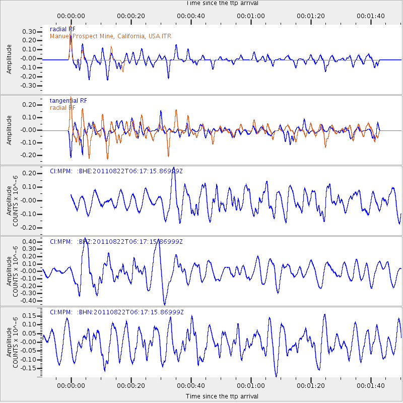
MPM Manuel Prospect Mine, California, USA - Earthquake Result Viewer
*The percent match for this event was below the threshold and hence no stack was calculated.
| Earthquake location: |
Vanuatu Islands |
| Earthquake latitude/longitude: |
-17.4/167.3 |
| Earthquake time(UTC): |
2011/08/22 (234) 06:04:53 GMT |
| Earthquake Depth: |
10 km |
| Earthquake Magnitude: |
5.7 MW, 5.2 MS, 5.4 MB, 5.7 MW |
| Earthquake Catalog/Contributor: |
WHDF/NEIC |
|
| Network: |
CI Caltech Regional Seismic Network |
| Station: |
MPM Manuel Prospect Mine, California, USA |
| Lat/Lon: |
36.06 N/117.49 W |
| Elevation: |
185 m |
|
| Distance: |
88.7 deg |
| Az: |
51.607 deg |
| Baz: |
247.43 deg |
| Ray Param: |
$rayparam |
*The percent match for this event was below the threshold and hence was not used in the summary stack. |
|
| Radial Match: |
59.442158 % |
| Radial Bump: |
400 |
| Transverse Match: |
57.25264 % |
| Transverse Bump: |
400 |
| SOD ConfigId: |
414626 |
| Insert Time: |
2012-01-13 05:55:58.510 +0000 |
| GWidth: |
2.5 |
| Max Bumps: |
400 |
| Tol: |
0.001 |
|
Signal To Noise
| Channel | StoN | STA | LTA |
| CI:MPM: :BHZ:20110822T06:17:15.86999Z | 3.5475254 | 2.184102E-7 | 6.1566915E-8 |
| CI:MPM: :BHN:20110822T06:17:15.86999Z | 1.467215 | 6.442484E-8 | 4.3909615E-8 |
| CI:MPM: :BHE:20110822T06:17:15.86999Z | 2.6924787 | 1.2577824E-7 | 4.671467E-8 |
| Arrivals |
| Ps | |
| PpPs | |
| PsPs/PpSs | |


