You are here: Home > Network List > NE - New England Seismic Network Stations List
> Station HNH Hanover, NH, USA > Earthquake Result Viewer
HNH Hanover, NH, USA - Earthquake Result Viewer
| Earthquake location: |
Near Coast Of Northern Chile |
| Earthquake latitude/longitude: |
-20.6/-70.7 |
| Earthquake time(UTC): |
2014/04/04 (094) 01:37:51 GMT |
| Earthquake Depth: |
20 km |
| Earthquake Magnitude: |
6.1 MWP, 6.1 MWB, 6.1 MWW, 6.3 MWC |
| Earthquake Catalog/Contributor: |
NEIC PDE/NEIC COMCAT |
|
| Network: |
NE New England Seismic Network |
| Station: |
HNH Hanover, NH, USA |
| Lat/Lon: |
43.71 N/72.29 W |
| Elevation: |
180 m |
|
| Distance: |
64.0 deg |
| Az: |
358.752 deg |
| Baz: |
178.388 deg |
| Ray Param: |
0.059170775 |
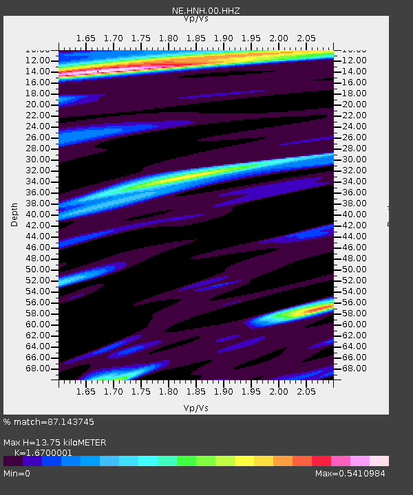
| Estimated Moho Depth: |
13.75 km |
| Estimated Crust Vp/Vs: |
1.67 |
| Assumed Crust Vp: |
6.419 km/s |
| Estimated Crust Vs: |
3.844 km/s |
| Estimated Crust Poisson's Ratio: |
0.22 |
|
| Radial Match: |
87.143745 % |
| Radial Bump: |
247 |
| Transverse Match: |
69.36212 % |
| Transverse Bump: |
400 |
| SOD ConfigId: |
3390531 |
| Insert Time: |
2019-04-11 03:32:02.585 +0000 |
| GWidth: |
2.5 |
| Max Bumps: |
400 |
| Tol: |
0.001 |
|

Signal To Noise
| Channel | StoN | STA | LTA |
| NE:HNH:00:HHZ:20140404T01:47:52.559016Z | 12.908416 | 1.964108E-6 | 1.5215717E-7 |
| NE:HNH:00:HH1:20140404T01:47:52.559016Z | 3.7058027 | 6.9301916E-7 | 1.8700919E-7 |
| NE:HNH:00:HH2:20140404T01:47:52.559016Z | 2.497493 | 4.4155195E-7 | 1.7679807E-7 |
| Arrivals |
| Ps | 1.5 SECOND |
| PpPs | 5.5 SECOND |
| PsPs/PpSs | 7.0 SECOND |


