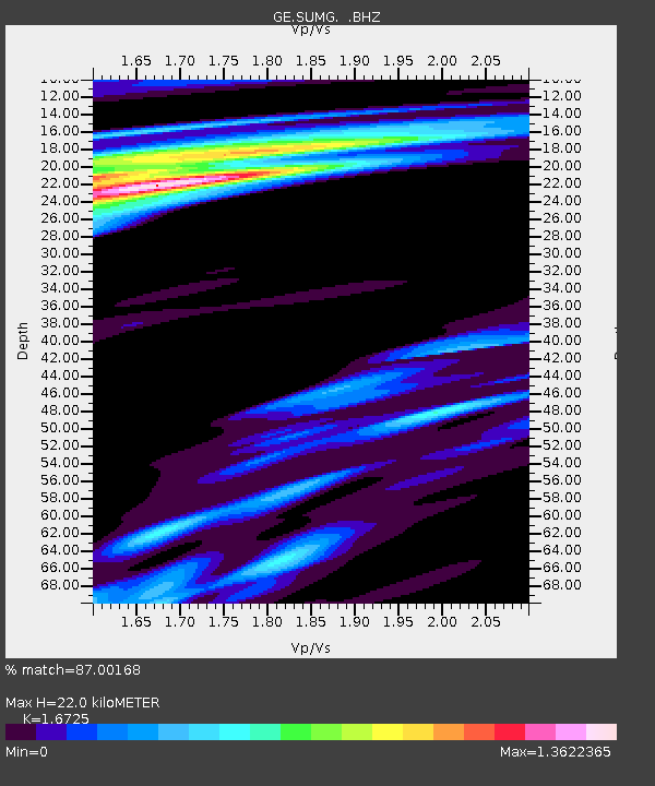
SUMG GEOFON Station Summit Camp, Greenland - Earthquake Result Viewer

Earthquake location: Near East Coast Of Honshu, Japan
Earthquake latitude/longitude: 36.1/141.7
Earthquake time(UTC): 2011/08/22 (234) 11:23:35 GMT
Earthquake Depth: 12 km
Earthquake Magnitude: 5.5 MB, 5.8 MS, 6.0 MW, 5.8 MW
Earthquake Catalog/Contributor: WHDF/NEIC
Network: GE GEOFON
Station: SUMG GEOFON Station Summit Camp, Greenland
Lat/Lon: 72.58 N/38.45 W
Elevation: 3240 m
Distance: 71.6 deg
Az: 0.045 deg
Baz: 359.879 deg
Ray Param: 0.054193366
Estimated Moho Depth: 22.0 km
Estimated Crust Vp/Vs: 1.67
Assumed Crust Vp: 6.261 km/s
Estimated Crust Vs: 3.743 km/s
Estimated Crust Poisson's Ratio: 0.22
Radial Match: 87.00168 %
Radial Bump: 400
Transverse Match: 63.63835 %
Transverse Bump: 385
SOD ConfigId: 414626
Insert Time: 2012-01-13 06:16:41.410 +0000
GWidth: 2.5
Max Bumps: 400
Tol: 0.001

Signal To Noise

ChannelStoNSTALTA
GE:SUMG: :BHZ:20110822T11:34:25.294983Z9.78371051.0612854E-61.0847473E-7
GE:SUMG: :BHN:20110822T11:34:25.294983Z1.46776811.988724E-71.3549307E-7
GE:SUMG: :BHE:20110822T11:34:25.294983Z0.8305528.765087E-81.05533275E-7
Arrivals
Ps2.4 SECOND
PpPs9.1 SECOND
PsPs/PpSs12 SECOND