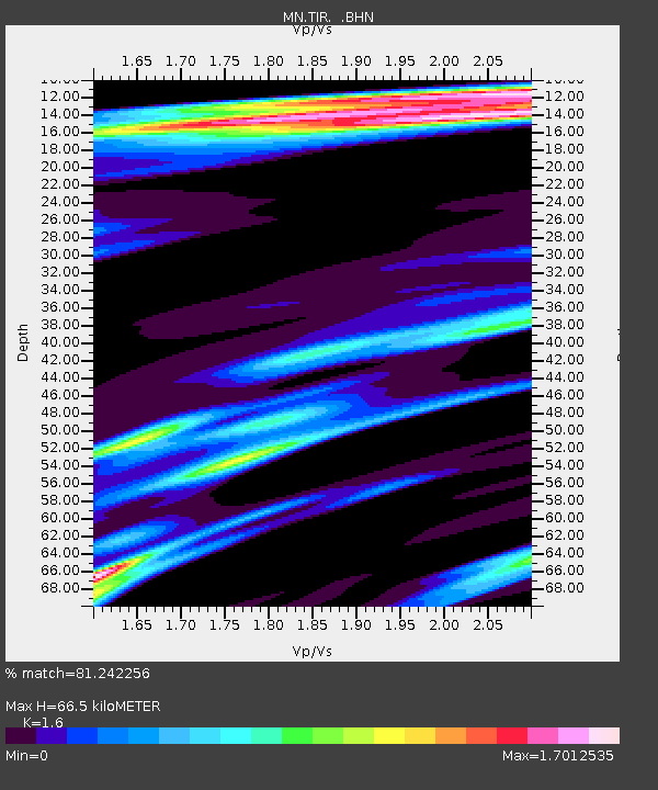
TIR Tirana, Albania - Earthquake Result Viewer
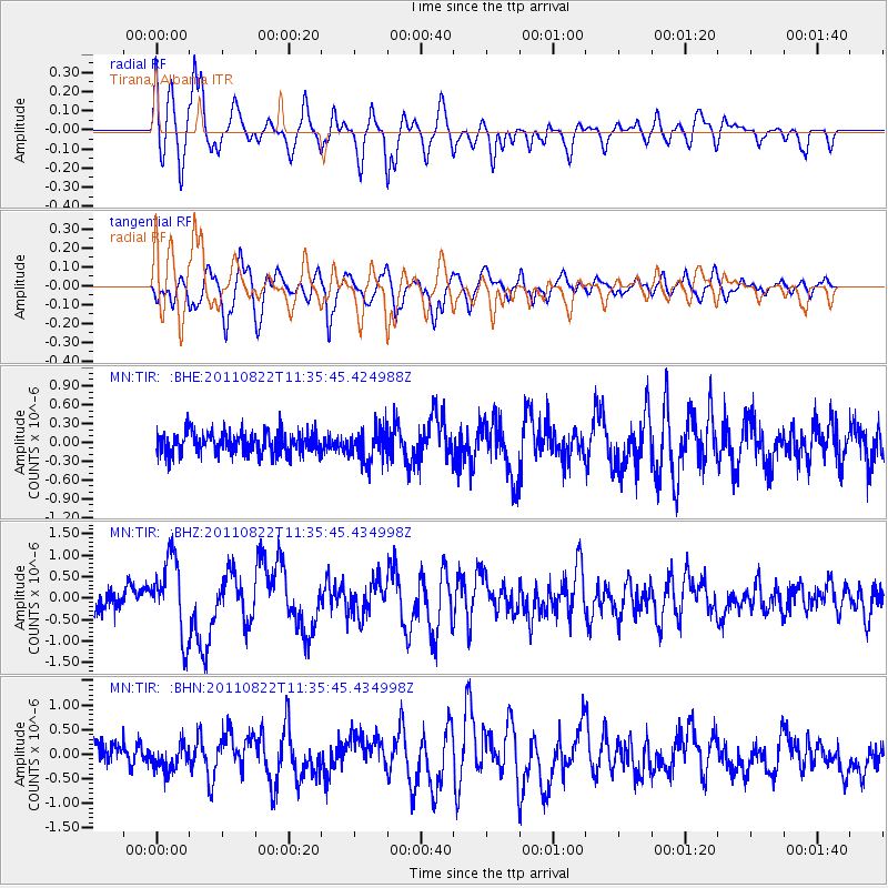
Earthquake location: Near East Coast Of Honshu, Japan
Earthquake latitude/longitude: 36.1/141.7
Earthquake time(UTC): 2011/08/22 (234) 11:23:35 GMT
Earthquake Depth: 12 km
Earthquake Magnitude: 5.5 MB, 5.8 MS, 6.0 MW, 5.8 MW
Earthquake Catalog/Contributor: WHDF/NEIC
Network: MN MEDNET Project
Station: TIR Tirana, Albania
Lat/Lon: 41.35 N/19.86 E
Elevation: 247 m
Distance: 86.3 deg
Az: 320.13 deg
Baz: 43.606 deg
Ray Param: 0.04413667
Estimated Moho Depth: 66.5 km
Estimated Crust Vp/Vs: 1.60
Assumed Crust Vp: 5.967 km/s
Estimated Crust Vs: 3.729 km/s
Estimated Crust Poisson's Ratio: 0.18
Radial Match: 81.242256 %
Radial Bump: 400
Transverse Match: 82.63073 %
Transverse Bump: 400
SOD ConfigId: 414626
Insert Time: 2012-01-13 06:19:54.365 +0000
GWidth: 2.5
Max Bumps: 400
Tol: 0.001

Signal To Noise

ChannelStoNSTALTA
MN:TIR: :BHZ:20110822T11:35:45.434998Z3.7528899.025205E-72.4048688E-7
MN:TIR: :BHN:20110822T11:35:45.434998Z1.1052652.9044017E-72.6277877E-7
MN:TIR: :BHE:20110822T11:35:45.424988Z1.5006972.588661E-71.7249725E-7
Arrivals
Ps6.8 SECOND
PpPs28 SECOND
PsPs/PpSs35 SECOND