You are here: Home > Network List > TA - USArray Transportable Network (new EarthScope stations) Stations List
> Station 534A Blanco, TX, USA > Earthquake Result Viewer
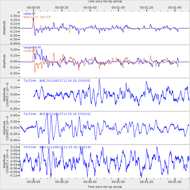
534A Blanco, TX, USA - Earthquake Result Viewer
*The percent match for this event was below the threshold and hence no stack was calculated.
| Earthquake location: |
Near East Coast Of Honshu, Japan |
| Earthquake latitude/longitude: |
36.1/141.7 |
| Earthquake time(UTC): |
2011/08/22 (234) 11:23:35 GMT |
| Earthquake Depth: |
12 km |
| Earthquake Magnitude: |
5.5 MB, 5.8 MS, 6.0 MW, 5.8 MW |
| Earthquake Catalog/Contributor: |
WHDF/NEIC |
|
| Network: |
TA USArray Transportable Network (new EarthScope stations) |
| Station: |
534A Blanco, TX, USA |
| Lat/Lon: |
30.03 N/98.48 W |
| Elevation: |
461 m |
|
| Distance: |
93.3 deg |
| Az: |
48.896 deg |
| Baz: |
315.265 deg |
| Ray Param: |
$rayparam |
*The percent match for this event was below the threshold and hence was not used in the summary stack. |
|
| Radial Match: |
77.53463 % |
| Radial Bump: |
400 |
| Transverse Match: |
66.64988 % |
| Transverse Bump: |
400 |
| SOD ConfigId: |
414626 |
| Insert Time: |
2012-01-13 06:26:39.055 +0000 |
| GWidth: |
2.5 |
| Max Bumps: |
400 |
| Tol: |
0.001 |
|
Signal To Noise
| Channel | StoN | STA | LTA |
| TA:534A: :BHZ:20110822T11:36:18.150024Z | 2.2098598 | 1.3371589E-7 | 6.050877E-8 |
| TA:534A: :BHN:20110822T11:36:18.150024Z | 1.2024587 | 4.665446E-8 | 3.8799218E-8 |
| TA:534A: :BHE:20110822T11:36:18.150024Z | 1.7493528 | 6.4262615E-8 | 3.6735077E-8 |
| Arrivals |
| Ps | |
| PpPs | |
| PsPs/PpSs | |


