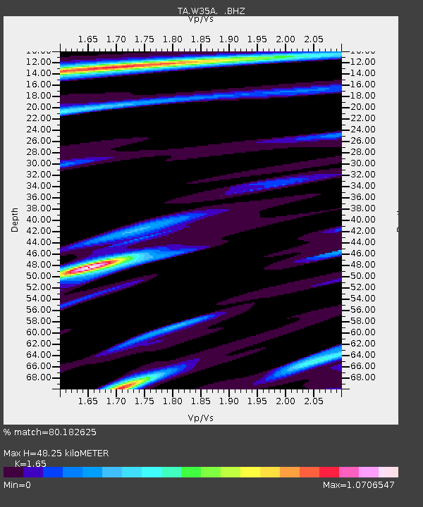
W35A Tecumseh, OK, USA - Earthquake Result Viewer

Earthquake location: Near East Coast Of Honshu, Japan
Earthquake latitude/longitude: 36.1/141.7
Earthquake time(UTC): 2011/08/22 (234) 11:23:35 GMT
Earthquake Depth: 12 km
Earthquake Magnitude: 5.5 MB, 5.8 MS, 6.0 MW, 5.8 MW
Earthquake Catalog/Contributor: WHDF/NEIC
Network: TA USArray Transportable Network (new EarthScope stations)
Station: W35A Tecumseh, OK, USA
Lat/Lon: 35.15 N/96.87 W
Elevation: 322 m
Distance: 90.6 deg
Az: 44.362 deg
Baz: 316.277 deg
Ray Param: 0.04166297
Estimated Moho Depth: 48.25 km
Estimated Crust Vp/Vs: 1.65
Assumed Crust Vp: 6.426 km/s
Estimated Crust Vs: 3.895 km/s
Estimated Crust Poisson's Ratio: 0.21
Radial Match: 80.182625 %
Radial Bump: 400
Transverse Match: 72.156654 %
Transverse Bump: 400
SOD ConfigId: 414626
Insert Time: 2012-01-13 06:29:11.124 +0000
GWidth: 2.5
Max Bumps: 400
Tol: 0.001

Signal To Noise

ChannelStoNSTALTA
TA:W35A: :BHZ:20110822T11:36:05.625Z2.6445992.415996E-79.135585E-8
TA:W35A: :BHN:20110822T11:36:05.625Z1.05745411.019025E-79.636588E-8
TA:W35A: :BHE:20110822T11:36:05.625Z0.826101366.479931E-87.84399E-8
Arrivals
Ps5.0 SECOND
PpPs19 SECOND
PsPs/PpSs24 SECOND