You are here: Home > Network List > TA - USArray Transportable Network (new EarthScope stations) Stations List
> Station R35A Emporia Municipal Airport, Emporia, KS, USA > Earthquake Result Viewer
R35A Emporia Municipal Airport, Emporia, KS, USA - Earthquake Result Viewer
| Earthquake location: |
Near East Coast Of Honshu, Japan |
| Earthquake latitude/longitude: |
36.1/141.7 |
| Earthquake time(UTC): |
2011/08/22 (234) 11:23:35 GMT |
| Earthquake Depth: |
12 km |
| Earthquake Magnitude: |
5.5 MB, 5.8 MS, 6.0 MW, 5.8 MW |
| Earthquake Catalog/Contributor: |
WHDF/NEIC |
|
| Network: |
TA USArray Transportable Network (new EarthScope stations) |
| Station: |
R35A Emporia Municipal Airport, Emporia, KS, USA |
| Lat/Lon: |
38.32 N/96.20 W |
| Elevation: |
365 m |
|
| Distance: |
88.7 deg |
| Az: |
41.789 deg |
| Baz: |
316.663 deg |
| Ray Param: |
0.042418625 |
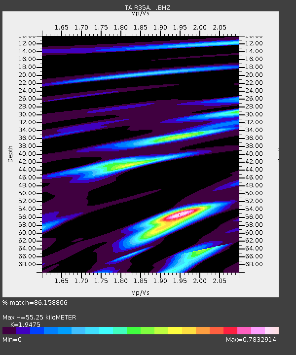
| Estimated Moho Depth: |
55.25 km |
| Estimated Crust Vp/Vs: |
1.95 |
| Assumed Crust Vp: |
6.483 km/s |
| Estimated Crust Vs: |
3.329 km/s |
| Estimated Crust Poisson's Ratio: |
0.32 |
|
| Radial Match: |
86.158806 % |
| Radial Bump: |
400 |
| Transverse Match: |
59.45996 % |
| Transverse Bump: |
400 |
| SOD ConfigId: |
414626 |
| Insert Time: |
2012-01-13 06:30:19.386 +0000 |
| GWidth: |
2.5 |
| Max Bumps: |
400 |
| Tol: |
0.001 |
|

Signal To Noise
| Channel | StoN | STA | LTA |
| TA:R35A: :BHZ:20110822T11:35:56.674988Z | 3.6335196 | 4.2300968E-7 | 1.1641871E-7 |
| TA:R35A: :BHN:20110822T11:35:56.674988Z | 1.5306122 | 1.7013403E-7 | 1.1115423E-7 |
| TA:R35A: :BHE:20110822T11:35:56.674988Z | 1.6445037 | 1.8194692E-7 | 1.10639405E-7 |
| Arrivals |
| Ps | 8.2 SECOND |
| PpPs | 25 SECOND |
| PsPs/PpSs | 33 SECOND |


