You are here: Home > Network List > TA - USArray Transportable Network (new EarthScope stations) Stations List
> Station E34A Wadena, MN, USA > Earthquake Result Viewer
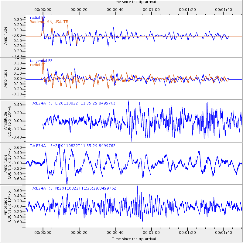
E34A Wadena, MN, USA - Earthquake Result Viewer
*The percent match for this event was below the threshold and hence no stack was calculated.
| Earthquake location: |
Near East Coast Of Honshu, Japan |
| Earthquake latitude/longitude: |
36.1/141.7 |
| Earthquake time(UTC): |
2011/08/22 (234) 11:23:35 GMT |
| Earthquake Depth: |
12 km |
| Earthquake Magnitude: |
5.5 MB, 5.8 MS, 6.0 MW, 5.8 MW |
| Earthquake Catalog/Contributor: |
WHDF/NEIC |
|
| Network: |
TA USArray Transportable Network (new EarthScope stations) |
| Station: |
E34A Wadena, MN, USA |
| Lat/Lon: |
46.51 N/95.17 W |
| Elevation: |
430 m |
|
| Distance: |
83.2 deg |
| Az: |
35.615 deg |
| Baz: |
316.918 deg |
| Ray Param: |
$rayparam |
*The percent match for this event was below the threshold and hence was not used in the summary stack. |
|
| Radial Match: |
68.37147 % |
| Radial Bump: |
400 |
| Transverse Match: |
51.303005 % |
| Transverse Bump: |
400 |
| SOD ConfigId: |
414626 |
| Insert Time: |
2012-01-13 06:34:04.360 +0000 |
| GWidth: |
2.5 |
| Max Bumps: |
400 |
| Tol: |
0.001 |
|
Signal To Noise
| Channel | StoN | STA | LTA |
| TA:E34A: :BHZ:20110822T11:35:29.849976Z | 4.105569 | 2.8206753E-7 | 6.870364E-8 |
| TA:E34A: :BHN:20110822T11:35:29.849976Z | 1.3347368 | 1.385765E-7 | 1.0382308E-7 |
| TA:E34A: :BHE:20110822T11:35:29.849976Z | 0.98987746 | 7.7962355E-8 | 7.87596E-8 |
| Arrivals |
| Ps | |
| PpPs | |
| PsPs/PpSs | |


