You are here: Home > Network List > TA - USArray Transportable Network (new EarthScope stations) Stations List
> Station M37A Trindle Farm, Earlham, IA, USA > Earthquake Result Viewer
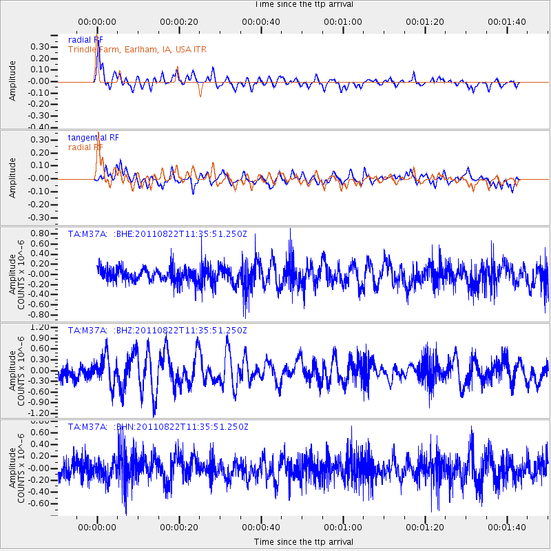
M37A Trindle Farm, Earlham, IA, USA - Earthquake Result Viewer
*The percent match for this event was below the threshold and hence no stack was calculated.
| Earthquake location: |
Near East Coast Of Honshu, Japan |
| Earthquake latitude/longitude: |
36.1/141.7 |
| Earthquake time(UTC): |
2011/08/22 (234) 11:23:35 GMT |
| Earthquake Depth: |
12 km |
| Earthquake Magnitude: |
5.5 MB, 5.8 MS, 6.0 MW, 5.8 MW |
| Earthquake Catalog/Contributor: |
WHDF/NEIC |
|
| Network: |
TA USArray Transportable Network (new EarthScope stations) |
| Station: |
M37A Trindle Farm, Earlham, IA, USA |
| Lat/Lon: |
41.40 N/94.06 W |
| Elevation: |
325 m |
|
| Distance: |
87.5 deg |
| Az: |
38.49 deg |
| Baz: |
317.92 deg |
| Ray Param: |
$rayparam |
*The percent match for this event was below the threshold and hence was not used in the summary stack. |
|
| Radial Match: |
72.18746 % |
| Radial Bump: |
400 |
| Transverse Match: |
60.000195 % |
| Transverse Bump: |
400 |
| SOD ConfigId: |
414626 |
| Insert Time: |
2012-01-13 06:37:43.030 +0000 |
| GWidth: |
2.5 |
| Max Bumps: |
400 |
| Tol: |
0.001 |
|
Signal To Noise
| Channel | StoN | STA | LTA |
| TA:M37A: :BHZ:20110822T11:35:51.250Z | 2.9168653 | 4.1288186E-7 | 1.4154985E-7 |
| TA:M37A: :BHN:20110822T11:35:51.250Z | 1.0846044 | 1.3401082E-7 | 1.2355733E-7 |
| TA:M37A: :BHE:20110822T11:35:51.250Z | 1.2952219 | 1.6128435E-7 | 1.2452256E-7 |
| Arrivals |
| Ps | |
| PpPs | |
| PsPs/PpSs | |


