You are here: Home > Network List > TA - USArray Transportable Network (new EarthScope stations) Stations List
> Station L39A Vinton, IA, USA > Earthquake Result Viewer
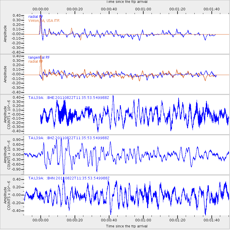
L39A Vinton, IA, USA - Earthquake Result Viewer
*The percent match for this event was below the threshold and hence no stack was calculated.
| Earthquake location: |
Near East Coast Of Honshu, Japan |
| Earthquake latitude/longitude: |
36.1/141.7 |
| Earthquake time(UTC): |
2011/08/22 (234) 11:23:35 GMT |
| Earthquake Depth: |
12 km |
| Earthquake Magnitude: |
5.5 MB, 5.8 MS, 6.0 MW, 5.8 MW |
| Earthquake Catalog/Contributor: |
WHDF/NEIC |
|
| Network: |
TA USArray Transportable Network (new EarthScope stations) |
| Station: |
L39A Vinton, IA, USA |
| Lat/Lon: |
42.12 N/92.00 W |
| Elevation: |
261 m |
|
| Distance: |
88.0 deg |
| Az: |
36.859 deg |
| Baz: |
319.221 deg |
| Ray Param: |
$rayparam |
*The percent match for this event was below the threshold and hence was not used in the summary stack. |
|
| Radial Match: |
77.431274 % |
| Radial Bump: |
400 |
| Transverse Match: |
54.763542 % |
| Transverse Bump: |
400 |
| SOD ConfigId: |
414626 |
| Insert Time: |
2012-01-13 06:41:04.530 +0000 |
| GWidth: |
2.5 |
| Max Bumps: |
400 |
| Tol: |
0.001 |
|
Signal To Noise
| Channel | StoN | STA | LTA |
| TA:L39A: :BHZ:20110822T11:35:53.549988Z | 3.525654 | 3.9458743E-7 | 1.1191893E-7 |
| TA:L39A: :BHN:20110822T11:35:53.549988Z | 1.1782837 | 9.941323E-8 | 8.4371216E-8 |
| TA:L39A: :BHE:20110822T11:35:53.549988Z | 1.2472591 | 1.589898E-7 | 1.2747134E-7 |
| Arrivals |
| Ps | |
| PpPs | |
| PsPs/PpSs | |


