You are here: Home > Network List > G - GEOSCOPE Stations List
> Station DRV Dumont d'Urville, Terre Adelie (Antartica) > Earthquake Result Viewer
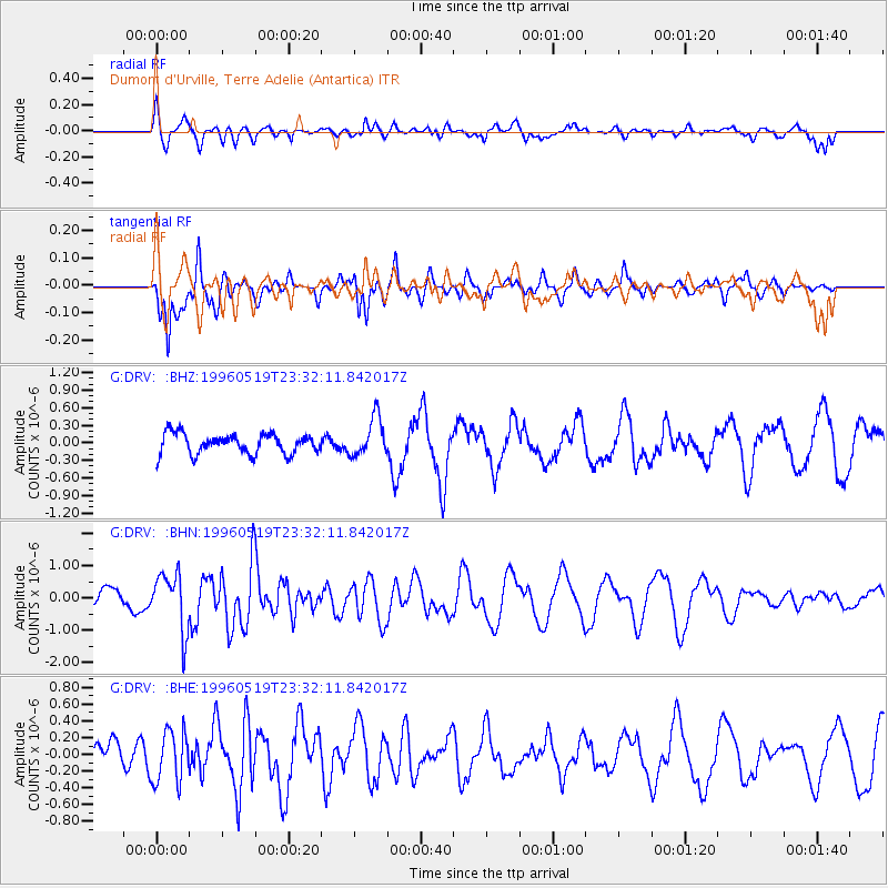
DRV Dumont d'Urville, Terre Adelie (Antartica) - Earthquake Result Viewer
*The percent match for this event was below the threshold and hence no stack was calculated.
| Earthquake location: |
Minahassa Peninsula, Sulawesi |
| Earthquake latitude/longitude: |
1.4/122.6 |
| Earthquake time(UTC): |
1996/05/19 (140) 23:21:40 GMT |
| Earthquake Depth: |
32 km |
| Earthquake Magnitude: |
5.8 UNKNOWN, 5.4 MS, 5.2 MB, 5.8 MW |
| Earthquake Catalog/Contributor: |
WHDF/NEIC |
|
| Network: |
G GEOSCOPE |
| Station: |
DRV Dumont d'Urville, Terre Adelie (Antartica) |
| Lat/Lon: |
66.67 S/140.01 E |
| Elevation: |
40 m |
|
| Distance: |
69.0 deg |
| Az: |
172.651 deg |
| Baz: |
341.276 deg |
| Ray Param: |
$rayparam |
*The percent match for this event was below the threshold and hence was not used in the summary stack. |
|
| Radial Match: |
42.978455 % |
| Radial Bump: |
400 |
| Transverse Match: |
82.257614 % |
| Transverse Bump: |
366 |
| SOD ConfigId: |
4480 |
| Insert Time: |
2010-02-26 22:11:12.546 +0000 |
| GWidth: |
2.5 |
| Max Bumps: |
400 |
| Tol: |
0.001 |
|
Signal To Noise
| Channel | StoN | STA | LTA |
| G:DRV: :BHN:19960519T23:32:11.842017Z | 2.4478831 | 8.808944E-7 | 3.5985965E-7 |
| G:DRV: :BHE:19960519T23:32:11.842017Z | 0.6597873 | 3.107069E-7 | 4.709198E-7 |
| G:DRV: :BHZ:19960519T23:32:11.842017Z | 1.9211048 | 3.3075713E-7 | 1.7217026E-7 |
| Arrivals |
| Ps | |
| PpPs | |
| PsPs/PpSs | |


