You are here: Home > Network List > TA - USArray Transportable Network (new EarthScope stations) Stations List
> Station H41A Junction City, WI, USA > Earthquake Result Viewer
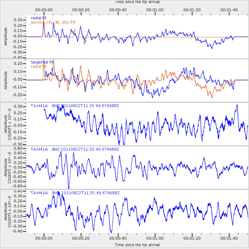
H41A Junction City, WI, USA - Earthquake Result Viewer
*The percent match for this event was below the threshold and hence no stack was calculated.
| Earthquake location: |
Near East Coast Of Honshu, Japan |
| Earthquake latitude/longitude: |
36.1/141.7 |
| Earthquake time(UTC): |
2011/08/22 (234) 11:23:35 GMT |
| Earthquake Depth: |
12 km |
| Earthquake Magnitude: |
5.5 MB, 5.8 MS, 6.0 MW, 5.8 MW |
| Earthquake Catalog/Contributor: |
WHDF/NEIC |
|
| Network: |
TA USArray Transportable Network (new EarthScope stations) |
| Station: |
H41A Junction City, WI, USA |
| Lat/Lon: |
44.62 N/89.65 W |
| Elevation: |
348 m |
|
| Distance: |
87.2 deg |
| Az: |
33.943 deg |
| Baz: |
320.705 deg |
| Ray Param: |
$rayparam |
*The percent match for this event was below the threshold and hence was not used in the summary stack. |
|
| Radial Match: |
43.760647 % |
| Radial Bump: |
400 |
| Transverse Match: |
23.78281 % |
| Transverse Bump: |
400 |
| SOD ConfigId: |
414626 |
| Insert Time: |
2012-01-13 06:42:31.515 +0000 |
| GWidth: |
2.5 |
| Max Bumps: |
400 |
| Tol: |
0.001 |
|
Signal To Noise
| Channel | StoN | STA | LTA |
| TA:H41A: :BHZ:20110822T11:35:49.674988Z | 3.1656091 | 2.5625764E-7 | 8.09505E-8 |
| TA:H41A: :BHN:20110822T11:35:49.674988Z | 0.54571 | 1.391163E-7 | 2.5492713E-7 |
| TA:H41A: :BHE:20110822T11:35:49.674988Z | 2.0304797 | 1.8395123E-7 | 9.0594966E-8 |
| Arrivals |
| Ps | |
| PpPs | |
| PsPs/PpSs | |


