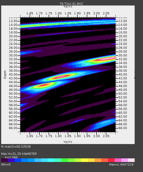
TOLK Tollok Lake Research Station, AK, USA - Earthquake Result Viewer

Earthquake location: Near East Coast Of Honshu, Japan
Earthquake latitude/longitude: 36.1/141.7
Earthquake time(UTC): 2011/08/22 (234) 11:23:35 GMT
Earthquake Depth: 12 km
Earthquake Magnitude: 5.5 MB, 5.8 MS, 6.0 MW, 5.8 MW
Earthquake Catalog/Contributor: WHDF/NEIC
Network: TA USArray Transportable Network (new EarthScope stations)
Station: TOLK Tollok Lake Research Station, AK, USA
Lat/Lon: 68.64 N/149.57 W
Elevation: 760 m
Distance: 49.2 deg
Az: 26.801 deg
Baz: 265.569 deg
Ray Param: 0.06883677
Estimated Moho Depth: 31.25 km
Estimated Crust Vp/Vs: 2.07
Assumed Crust Vp: 6.316 km/s
Estimated Crust Vs: 3.059 km/s
Estimated Crust Poisson's Ratio: 0.35
Radial Match: 80.02539 %
Radial Bump: 400
Transverse Match: 75.09003 %
Transverse Bump: 400
SOD ConfigId: 414626
Insert Time: 2012-01-13 06:42:56.989 +0000
GWidth: 2.5
Max Bumps: 400
Tol: 0.001

Signal To Noise

ChannelStoNSTALTA
TA:TOLK:01:BHZ:20110822T11:31:52.350006Z4.11006073.9243204E-79.548084E-8
TA:TOLK:01:BHN:20110822T11:31:52.350006Z0.99566681.5042237E-71.5107702E-7
TA:TOLK:01:BHE:20110822T11:31:52.350006Z1.61107871.9375506E-71.2026418E-7
Arrivals
Ps5.5 SECOND
PpPs14 SECOND
PsPs/PpSs20 SECOND