You are here: Home > Network List > HK - Hong Kong Seismographic Network Stations List
> Station HKPS Po Shan, Hong Kong > Earthquake Result Viewer
HKPS Po Shan, Hong Kong - Earthquake Result Viewer
| Earthquake location: |
Sunda Strait, Indonesia |
| Earthquake latitude/longitude: |
-6.3/104.1 |
| Earthquake time(UTC): |
2011/08/22 (234) 20:12:20 GMT |
| Earthquake Depth: |
29 km |
| Earthquake Magnitude: |
6.0 MB, 6.0 MS, 6.1 MW, 6.1 MW |
| Earthquake Catalog/Contributor: |
WHDF/NEIC |
|
| Network: |
HK Hong Kong Seismographic Network |
| Station: |
HKPS Po Shan, Hong Kong |
| Lat/Lon: |
22.28 N/114.14 E |
| Elevation: |
196 m |
|
| Distance: |
30.1 deg |
| Az: |
18.901 deg |
| Baz: |
200.344 deg |
| Ray Param: |
0.079407714 |
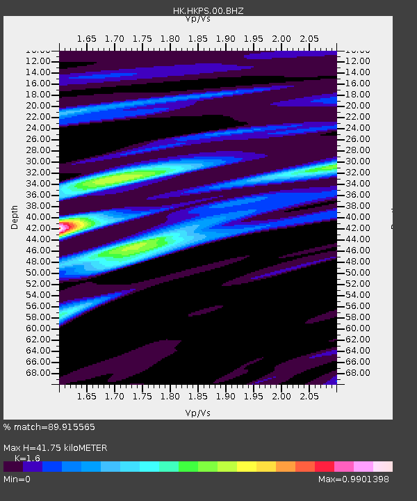
| Estimated Moho Depth: |
41.75 km |
| Estimated Crust Vp/Vs: |
1.60 |
| Assumed Crust Vp: |
6.472 km/s |
| Estimated Crust Vs: |
4.045 km/s |
| Estimated Crust Poisson's Ratio: |
0.18 |
|
| Radial Match: |
89.915565 % |
| Radial Bump: |
400 |
| Transverse Match: |
67.71627 % |
| Transverse Bump: |
400 |
| SOD ConfigId: |
414626 |
| Insert Time: |
2012-01-13 06:49:13.977 +0000 |
| GWidth: |
2.5 |
| Max Bumps: |
400 |
| Tol: |
0.001 |
|
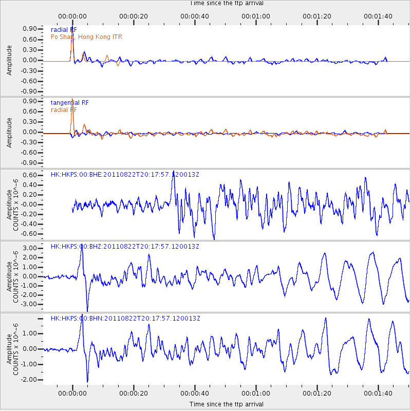
Signal To Noise
| Channel | StoN | STA | LTA |
| HK:HKPS:00:BHZ:20110822T20:17:57.120013Z | 15.44975 | 1.454224E-6 | 9.412606E-8 |
| HK:HKPS:00:BHN:20110822T20:17:57.120013Z | 12.156546 | 9.0973396E-7 | 7.483491E-8 |
| HK:HKPS:00:BHE:20110822T20:17:57.120013Z | 3.9088502 | 2.8177146E-7 | 7.208551E-8 |
| Arrivals |
| Ps | 4.2 SECOND |
| PpPs | 15 SECOND |
| PsPs/PpSs | 20 SECOND |


