You are here: Home > Network List > MN - MEDNET Project Stations List
> Station IDI Anogia, Greece > Earthquake Result Viewer
IDI Anogia, Greece - Earthquake Result Viewer
| Earthquake location: |
Sunda Strait, Indonesia |
| Earthquake latitude/longitude: |
-6.3/104.1 |
| Earthquake time(UTC): |
2011/08/22 (234) 20:12:20 GMT |
| Earthquake Depth: |
29 km |
| Earthquake Magnitude: |
6.0 MB, 6.0 MS, 6.1 MW, 6.1 MW |
| Earthquake Catalog/Contributor: |
WHDF/NEIC |
|
| Network: |
MN MEDNET Project |
| Station: |
IDI Anogia, Greece |
| Lat/Lon: |
35.29 N/24.89 E |
| Elevation: |
750 m |
|
| Distance: |
84.8 deg |
| Az: |
306.216 deg |
| Baz: |
101.374 deg |
| Ray Param: |
0.045176573 |
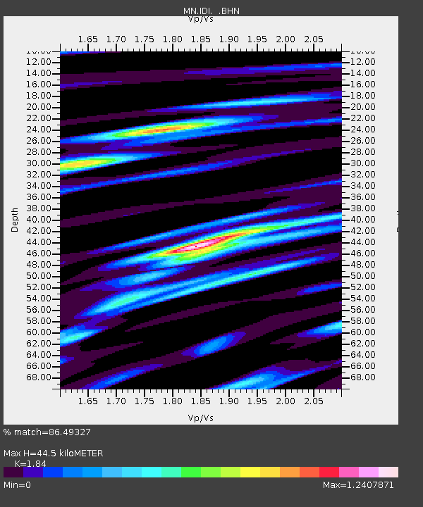
| Estimated Moho Depth: |
44.5 km |
| Estimated Crust Vp/Vs: |
1.84 |
| Assumed Crust Vp: |
5.627 km/s |
| Estimated Crust Vs: |
3.058 km/s |
| Estimated Crust Poisson's Ratio: |
0.29 |
|
| Radial Match: |
86.49327 % |
| Radial Bump: |
400 |
| Transverse Match: |
76.248184 % |
| Transverse Bump: |
400 |
| SOD ConfigId: |
414626 |
| Insert Time: |
2012-01-13 06:50:55.824 +0000 |
| GWidth: |
2.5 |
| Max Bumps: |
400 |
| Tol: |
0.001 |
|

Signal To Noise
| Channel | StoN | STA | LTA |
| MN:IDI: :BHZ:20110822T20:24:21.335986Z | 5.418725 | 1.310662E-6 | 2.4187648E-7 |
| MN:IDI: :BHN:20110822T20:24:21.335986Z | 2.0544994 | 3.3306742E-7 | 1.6211611E-7 |
| MN:IDI: :BHE:20110822T20:24:21.335986Z | 2.1584022 | 4.679372E-7 | 2.1679797E-7 |
| Arrivals |
| Ps | 6.8 SECOND |
| PpPs | 22 SECOND |
| PsPs/PpSs | 29 SECOND |


