You are here: Home > Network List > MN - MEDNET Project Stations List
> Station TRI Trieste, Italy > Earthquake Result Viewer
TRI Trieste, Italy - Earthquake Result Viewer
| Earthquake location: |
Sunda Strait, Indonesia |
| Earthquake latitude/longitude: |
-6.3/104.1 |
| Earthquake time(UTC): |
2011/08/22 (234) 20:12:20 GMT |
| Earthquake Depth: |
29 km |
| Earthquake Magnitude: |
6.0 MB, 6.0 MS, 6.1 MW, 6.1 MW |
| Earthquake Catalog/Contributor: |
WHDF/NEIC |
|
| Network: |
MN MEDNET Project |
| Station: |
TRI Trieste, Italy |
| Lat/Lon: |
45.71 N/13.76 E |
| Elevation: |
161 m |
|
| Distance: |
94.7 deg |
| Az: |
315.331 deg |
| Baz: |
94.176 deg |
| Ray Param: |
0.040979624 |
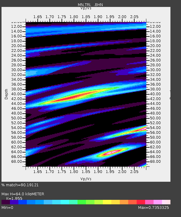
| Estimated Moho Depth: |
64.0 km |
| Estimated Crust Vp/Vs: |
1.96 |
| Assumed Crust Vp: |
6.207 km/s |
| Estimated Crust Vs: |
3.175 km/s |
| Estimated Crust Poisson's Ratio: |
0.32 |
|
| Radial Match: |
90.19121 % |
| Radial Bump: |
400 |
| Transverse Match: |
80.55515 % |
| Transverse Bump: |
400 |
| SOD ConfigId: |
414626 |
| Insert Time: |
2012-01-13 06:51:05.201 +0000 |
| GWidth: |
2.5 |
| Max Bumps: |
400 |
| Tol: |
0.001 |
|
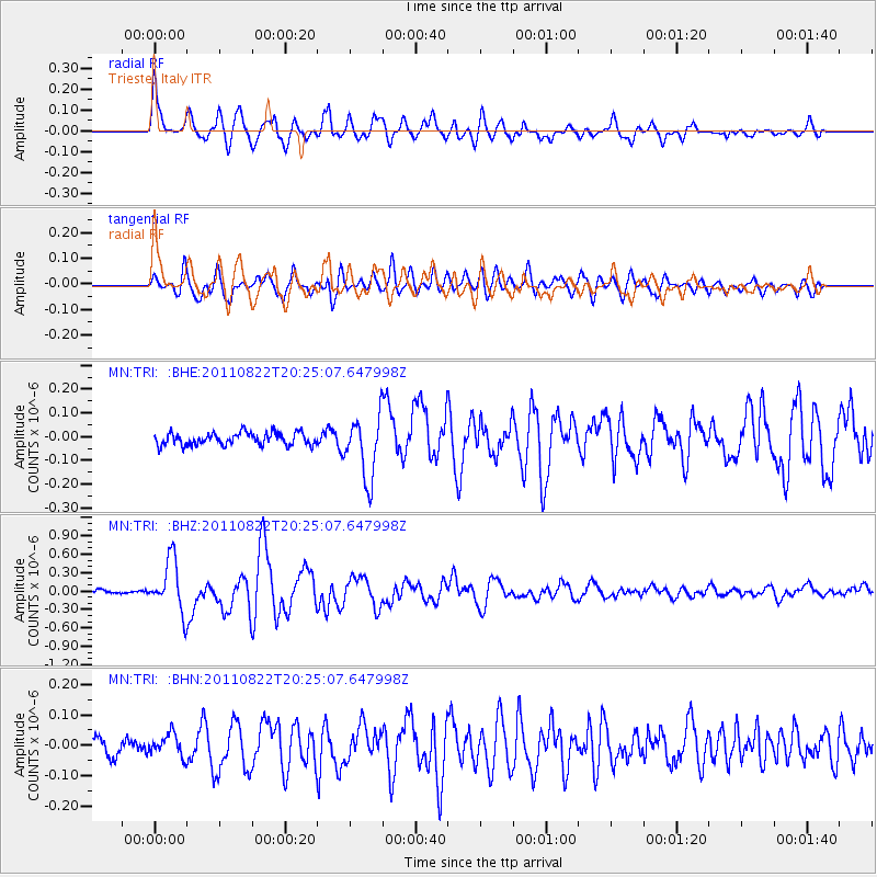
Signal To Noise
| Channel | StoN | STA | LTA |
| MN:TRI: :BHZ:20110822T20:25:07.647998Z | 14.109465 | 4.2357786E-7 | 3.0020832E-8 |
| MN:TRI: :BHN:20110822T20:25:07.647998Z | 1.0921106 | 3.9040664E-8 | 3.5747902E-8 |
| MN:TRI: :BHE:20110822T20:25:07.647998Z | 5.0581636 | 1.3075449E-7 | 2.585019E-8 |
| Arrivals |
| Ps | 10 SECOND |
| PpPs | 30 SECOND |
| PsPs/PpSs | 40 SECOND |


