You are here: Home > Network List > MN - MEDNET Project Stations List
> Station CEL Celeste, Italy > Earthquake Result Viewer
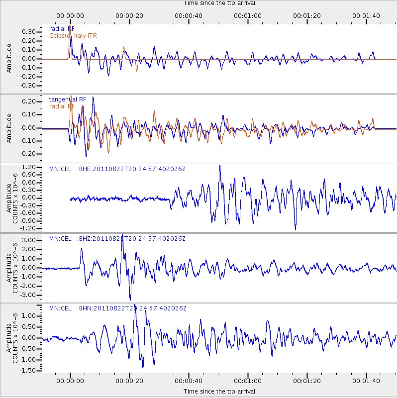
CEL Celeste, Italy - Earthquake Result Viewer

| Earthquake location: |
Sunda Strait, Indonesia |
| Earthquake latitude/longitude: |
-6.3/104.1 |
| Earthquake time(UTC): |
2011/08/22 (234) 20:12:20 GMT |
| Earthquake Depth: |
29 km |
| Earthquake Magnitude: |
6.0 MB, 6.0 MS, 6.1 MW, 6.1 MW |
| Earthquake Catalog/Contributor: |
WHDF/NEIC |
|
| Network: |
MN MEDNET Project |
| Station: |
CEL Celeste, Italy |
| Lat/Lon: |
38.26 N/15.89 E |
| Elevation: |
702 m |
|
| Distance: |
92.4 deg |
| Az: |
308.047 deg |
| Baz: |
96.047 deg |
| Ray Param: |
0.041456714 |
| Estimated Moho Depth: |
59.0 km |
| Estimated Crust Vp/Vs: |
1.85 |
| Assumed Crust Vp: |
5.782 km/s |
| Estimated Crust Vs: |
3.126 km/s |
| Estimated Crust Poisson's Ratio: |
0.29 |
|
| Radial Match: |
95.10722 % |
| Radial Bump: |
400 |
| Transverse Match: |
95.13006 % |
| Transverse Bump: |
400 |
| SOD ConfigId: |
414626 |
| Insert Time: |
2012-01-13 06:51:20.087 +0000 |
| GWidth: |
2.5 |
| Max Bumps: |
400 |
| Tol: |
0.001 |
|
Signal To Noise
| Channel | StoN | STA | LTA |
| MN:CEL: :BHZ:20110822T20:24:57.402026Z | 13.550141 | 7.0293004E-7 | 5.1876214E-8 |
| MN:CEL: :BHN:20110822T20:24:57.402026Z | 1.1625643 | 6.224808E-8 | 5.3543776E-8 |
| MN:CEL: :BHE:20110822T20:24:57.402026Z | 2.6909094 | 1.2675241E-7 | 4.7103928E-8 |
| Arrivals |
| Ps | 8.8 SECOND |
| PpPs | 29 SECOND |
| PsPs/PpSs | 37 SECOND |


