You are here: Home > Network List > TW - Broadband Array in Taiwan for Seismology Stations List
> Station YHNB YE-HENG, Taoyuan > Earthquake Result Viewer
YHNB YE-HENG, Taoyuan - Earthquake Result Viewer
| Earthquake location: |
Sunda Strait, Indonesia |
| Earthquake latitude/longitude: |
-6.3/104.1 |
| Earthquake time(UTC): |
2011/08/22 (234) 20:12:20 GMT |
| Earthquake Depth: |
29 km |
| Earthquake Magnitude: |
6.0 MB, 6.0 MS, 6.1 MW, 6.1 MW |
| Earthquake Catalog/Contributor: |
WHDF/NEIC |
|
| Network: |
TW Broadband Array in Taiwan for Seismology |
| Station: |
YHNB YE-HENG, Taoyuan |
| Lat/Lon: |
24.67 N/121.37 E |
| Elevation: |
775 m |
|
| Distance: |
35.1 deg |
| Az: |
28.112 deg |
| Baz: |
210.988 deg |
| Ray Param: |
0.07735735 |
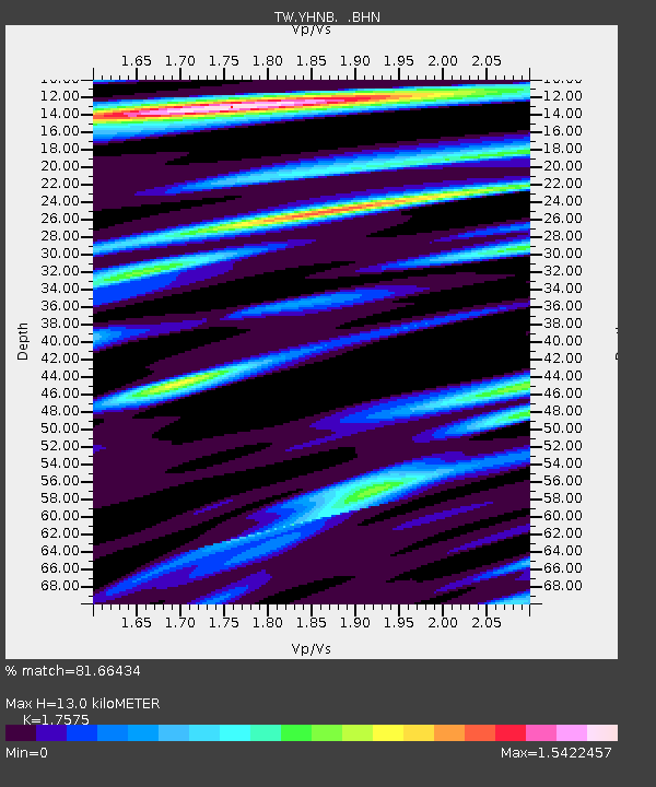
| Estimated Moho Depth: |
13.0 km |
| Estimated Crust Vp/Vs: |
1.76 |
| Assumed Crust Vp: |
6.289 km/s |
| Estimated Crust Vs: |
3.578 km/s |
| Estimated Crust Poisson's Ratio: |
0.26 |
|
| Radial Match: |
81.66434 % |
| Radial Bump: |
400 |
| Transverse Match: |
71.244125 % |
| Transverse Bump: |
400 |
| SOD ConfigId: |
414626 |
| Insert Time: |
2012-01-13 06:52:47.859 +0000 |
| GWidth: |
2.5 |
| Max Bumps: |
400 |
| Tol: |
0.001 |
|

Signal To Noise
| Channel | StoN | STA | LTA |
| TW:YHNB: :BHZ:20110822T20:18:41.020007Z | 21.453072 | 1.7471191E-6 | 8.1439104E-8 |
| TW:YHNB: :BHN:20110822T20:18:41.020007Z | 8.548559 | 6.4639244E-7 | 7.56142E-8 |
| TW:YHNB: :BHE:20110822T20:18:41.020007Z | 5.580698 | 4.5475514E-7 | 8.1487144E-8 |
| Arrivals |
| Ps | 1.7 SECOND |
| PpPs | 5.3 SECOND |
| PsPs/PpSs | 7.0 SECOND |


