You are here: Home > Network List > CI - Caltech Regional Seismic Network Stations List
> Station MPM Manuel Prospect Mine, California, USA > Earthquake Result Viewer
MPM Manuel Prospect Mine, California, USA - Earthquake Result Viewer
*The percent match for this event was below the threshold and hence no stack was calculated.
| Earthquake location: |
Virginia |
| Earthquake latitude/longitude: |
37.9/-77.9 |
| Earthquake time(UTC): |
2011/08/23 (235) 17:51:04 GMT |
| Earthquake Depth: |
6.0 km |
| Earthquake Magnitude: |
5.9 MB, 5.6 MS, 5.8 MW, 5.8 MW |
| Earthquake Catalog/Contributor: |
WHDF/NEIC |
|
| Network: |
CI Caltech Regional Seismic Network |
| Station: |
MPM Manuel Prospect Mine, California, USA |
| Lat/Lon: |
36.06 N/117.49 W |
| Elevation: |
185 m |
|
| Distance: |
31.5 deg |
| Az: |
278.909 deg |
| Baz: |
74.587 deg |
| Ray Param: |
$rayparam |
*The percent match for this event was below the threshold and hence was not used in the summary stack. |
|
| Radial Match: |
75.348694 % |
| Radial Bump: |
400 |
| Transverse Match: |
67.71662 % |
| Transverse Bump: |
400 |
| SOD ConfigId: |
414626 |
| Insert Time: |
2012-01-13 06:59:49.531 +0000 |
| GWidth: |
2.5 |
| Max Bumps: |
400 |
| Tol: |
0.001 |
|
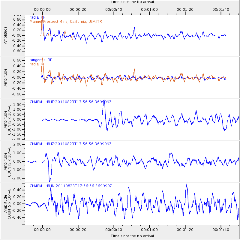
Signal To Noise
| Channel | StoN | STA | LTA |
| CI:MPM: :BHZ:20110823T17:56:56.369999Z | 19.389011 | 1.0494468E-6 | 5.4125856E-8 |
| CI:MPM: :BHN:20110823T17:56:56.369999Z | 2.6137166 | 1.5248656E-7 | 5.8340895E-8 |
| CI:MPM: :BHE:20110823T17:56:56.369999Z | 14.6885805 | 8.1446166E-7 | 5.544863E-8 |
| Arrivals |
| Ps | |
| PpPs | |
| PsPs/PpSs | |


