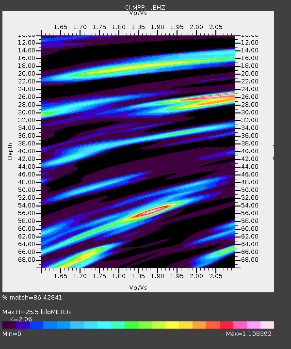
MPP McPhearson Peak - Earthquake Result Viewer
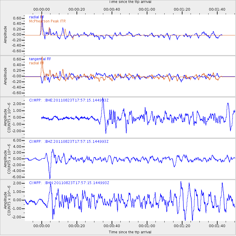
Earthquake location: Virginia
Earthquake latitude/longitude: 37.9/-77.9
Earthquake time(UTC): 2011/08/23 (235) 17:51:04 GMT
Earthquake Depth: 6.0 km
Earthquake Magnitude: 5.9 MB, 5.6 MS, 5.8 MW, 5.8 MW
Earthquake Catalog/Contributor: WHDF/NEIC
Network: CI Caltech Regional Seismic Network
Station: MPP McPhearson Peak
Lat/Lon: 34.89 N/119.81 W
Elevation: 1739 m
Distance: 33.6 deg
Az: 277.834 deg
Baz: 72.338 deg
Ray Param: 0.07812326
Estimated Moho Depth: 25.5 km
Estimated Crust Vp/Vs: 2.06
Assumed Crust Vp: 6.1 km/s
Estimated Crust Vs: 2.961 km/s
Estimated Crust Poisson's Ratio: 0.35
Radial Match: 86.42841 %
Radial Bump: 400
Transverse Match: 75.001526 %
Transverse Bump: 400
SOD ConfigId: 414626
Insert Time: 2012-01-13 07:01:07.772 +0000
GWidth: 2.5
Max Bumps: 400
Tol: 0.001

Signal To Noise

ChannelStoNSTALTA
CI:MPP: :BHZ:20110823T17:57:15.144993Z14.6750752.0980797E-61.4296893E-7
CI:MPP: :BHN:20110823T17:57:15.144993Z3.0716955.1867073E-71.6885488E-7
CI:MPP: :BHE:20110823T17:57:15.144993Z6.6833928.31641E-71.2443397E-7
Arrivals
Ps4.7 SECOND
PpPs12 SECOND
PsPs/PpSs17 SECOND