You are here: Home > Network List > Z910 - Southeastern Suture of the Appalachian Margin Experiment Stations List
> Station E31 Griffin Property, Waynesboro, GA > Earthquake Result Viewer
E31 Griffin Property, Waynesboro, GA - Earthquake Result Viewer
| Earthquake location: |
Near Coast Of Northern Chile |
| Earthquake latitude/longitude: |
-20.6/-70.7 |
| Earthquake time(UTC): |
2014/04/04 (094) 01:37:51 GMT |
| Earthquake Depth: |
20 km |
| Earthquake Magnitude: |
6.1 MWP, 6.1 MWB, 6.1 MWW, 6.3 MWC |
| Earthquake Catalog/Contributor: |
NEIC PDE/NEIC COMCAT |
|
| Network: |
Z9 Southeastern Suture of the Appalachian Margin Experiment |
| Station: |
E31 Griffin Property, Waynesboro, GA |
| Lat/Lon: |
32.99 N/82.11 W |
| Elevation: |
78 m |
|
| Distance: |
54.4 deg |
| Az: |
348.245 deg |
| Baz: |
166.876 deg |
| Ray Param: |
0.06544741 |
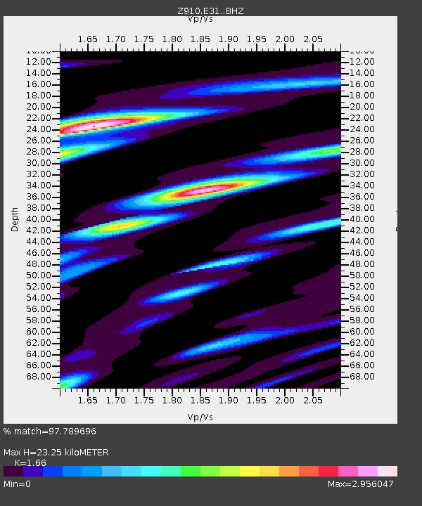
| Estimated Moho Depth: |
23.25 km |
| Estimated Crust Vp/Vs: |
1.66 |
| Assumed Crust Vp: |
6.565 km/s |
| Estimated Crust Vs: |
3.955 km/s |
| Estimated Crust Poisson's Ratio: |
0.22 |
|
| Radial Match: |
97.789696 % |
| Radial Bump: |
353 |
| Transverse Match: |
72.78661 % |
| Transverse Bump: |
400 |
| SOD ConfigId: |
3390531 |
| Insert Time: |
2019-04-11 03:38:02.814 +0000 |
| GWidth: |
2.5 |
| Max Bumps: |
400 |
| Tol: |
0.001 |
|

Signal To Noise
| Channel | StoN | STA | LTA |
| Z9:E31: :BHZ:20140404T01:46:46.35998Z | 17.547905 | 1.8222449E-6 | 1.03844016E-7 |
| Z9:E31: :BHN:20140404T01:46:46.35998Z | 10.197286 | 1.6151655E-6 | 1.5839171E-7 |
| Z9:E31: :BHE:20140404T01:46:46.35998Z | 2.2080286 | 3.823034E-7 | 1.7314241E-7 |
| Arrivals |
| Ps | 2.5 SECOND |
| PpPs | 8.9 SECOND |
| PsPs/PpSs | 11 SECOND |


