You are here: Home > Network List > DK - Danish Seismological Network Stations List
> Station TULEG Thule Air Base, Greenland > Earthquake Result Viewer
TULEG Thule Air Base, Greenland - Earthquake Result Viewer
| Earthquake location: |
Virginia |
| Earthquake latitude/longitude: |
37.9/-77.9 |
| Earthquake time(UTC): |
2011/08/23 (235) 17:51:04 GMT |
| Earthquake Depth: |
6.0 km |
| Earthquake Magnitude: |
5.9 MB, 5.6 MS, 5.8 MW, 5.8 MW |
| Earthquake Catalog/Contributor: |
WHDF/NEIC |
|
| Network: |
DK Danish Seismological Network |
| Station: |
TULEG Thule Air Base, Greenland |
| Lat/Lon: |
76.54 N/68.82 W |
| Elevation: |
38 m |
|
| Distance: |
38.9 deg |
| Az: |
3.385 deg |
| Baz: |
191.495 deg |
| Ray Param: |
0.07529701 |
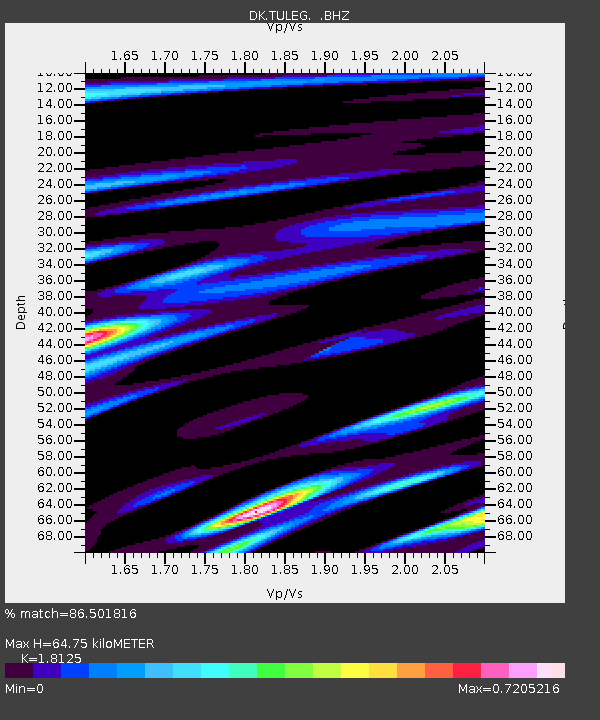
| Estimated Moho Depth: |
64.75 km |
| Estimated Crust Vp/Vs: |
1.81 |
| Assumed Crust Vp: |
6.459 km/s |
| Estimated Crust Vs: |
3.564 km/s |
| Estimated Crust Poisson's Ratio: |
0.28 |
|
| Radial Match: |
86.501816 % |
| Radial Bump: |
344 |
| Transverse Match: |
71.076096 % |
| Transverse Bump: |
400 |
| SOD ConfigId: |
414626 |
| Insert Time: |
2012-01-13 07:02:22.773 +0000 |
| GWidth: |
2.5 |
| Max Bumps: |
400 |
| Tol: |
0.001 |
|

Signal To Noise
| Channel | StoN | STA | LTA |
| DK:TULEG: :BHZ:20110823T17:58:00.149998Z | 23.747963 | 2.3264279E-6 | 9.796326E-8 |
| DK:TULEG: :BHN:20110823T17:58:00.149998Z | 13.990916 | 1.3809835E-6 | 9.870572E-8 |
| DK:TULEG: :BHE:20110823T17:58:00.149998Z | 6.5707684 | 4.7344776E-7 | 7.205364E-8 |
| Arrivals |
| Ps | 8.7 SECOND |
| PpPs | 26 SECOND |
| PsPs/PpSs | 35 SECOND |


