You are here: Home > Network List > G - GEOSCOPE Stations List
> Station CLF Chambon la Foret observatory, France > Earthquake Result Viewer
CLF Chambon la Foret observatory, France - Earthquake Result Viewer
| Earthquake location: |
Virginia |
| Earthquake latitude/longitude: |
37.9/-77.9 |
| Earthquake time(UTC): |
2011/08/23 (235) 17:51:04 GMT |
| Earthquake Depth: |
6.0 km |
| Earthquake Magnitude: |
5.9 MB, 5.6 MS, 5.8 MW, 5.8 MW |
| Earthquake Catalog/Contributor: |
WHDF/NEIC |
|
| Network: |
G GEOSCOPE |
| Station: |
CLF Chambon la Foret observatory, France |
| Lat/Lon: |
48.03 N/2.26 E |
| Elevation: |
145 m |
|
| Distance: |
57.0 deg |
| Az: |
52.039 deg |
| Baz: |
291.769 deg |
| Ray Param: |
0.06376231 |
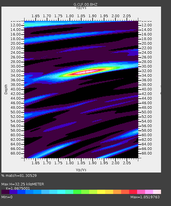
| Estimated Moho Depth: |
32.25 km |
| Estimated Crust Vp/Vs: |
1.87 |
| Assumed Crust Vp: |
6.12 km/s |
| Estimated Crust Vs: |
3.277 km/s |
| Estimated Crust Poisson's Ratio: |
0.30 |
|
| Radial Match: |
81.30529 % |
| Radial Bump: |
400 |
| Transverse Match: |
64.36667 % |
| Transverse Bump: |
400 |
| SOD ConfigId: |
414626 |
| Insert Time: |
2012-01-13 07:02:45.551 +0000 |
| GWidth: |
2.5 |
| Max Bumps: |
400 |
| Tol: |
0.001 |
|
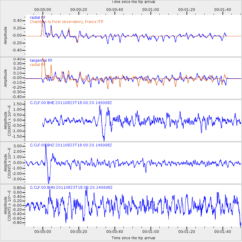
Signal To Noise
| Channel | StoN | STA | LTA |
| G:CLF:00:BHZ:20110823T18:00:20.149998Z | 11.812353 | 1.7259671E-6 | 1.4611543E-7 |
| G:CLF:00:BHN:20110823T18:00:20.149998Z | 1.6490893 | 2.7950594E-7 | 1.6949109E-7 |
| G:CLF:00:BHE:20110823T18:00:20.149998Z | 4.671204 | 8.8465936E-7 | 1.8938573E-7 |
| Arrivals |
| Ps | 4.8 SECOND |
| PpPs | 14 SECOND |
| PsPs/PpSs | 19 SECOND |


