You are here: Home > Network List > AZ - ANZA Regional Network Stations List
> Station SND AZ.SND > Earthquake Result Viewer
SND AZ.SND - Earthquake Result Viewer
| Earthquake location: |
Peru-Brazil Border Region |
| Earthquake latitude/longitude: |
-7.6/-74.5 |
| Earthquake time(UTC): |
2011/08/24 (236) 17:46:11 GMT |
| Earthquake Depth: |
147 km |
| Earthquake Magnitude: |
6.8 MB, 7.0 MW, 7.0 MW |
| Earthquake Catalog/Contributor: |
WHDF/NEIC |
|
| Network: |
AZ ANZA Regional Network |
| Station: |
SND AZ.SND |
| Lat/Lon: |
33.55 N/116.61 W |
| Elevation: |
1358 m |
|
| Distance: |
57.2 deg |
| Az: |
318.251 deg |
| Baz: |
127.78 deg |
| Ray Param: |
0.063183516 |
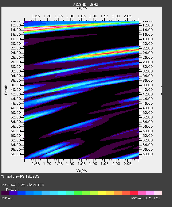
| Estimated Moho Depth: |
13.25 km |
| Estimated Crust Vp/Vs: |
1.64 |
| Assumed Crust Vp: |
6.264 km/s |
| Estimated Crust Vs: |
3.819 km/s |
| Estimated Crust Poisson's Ratio: |
0.20 |
|
| Radial Match: |
93.181335 % |
| Radial Bump: |
400 |
| Transverse Match: |
84.629395 % |
| Transverse Bump: |
400 |
| SOD ConfigId: |
414626 |
| Insert Time: |
2012-01-13 07:14:15.897 +0000 |
| GWidth: |
2.5 |
| Max Bumps: |
400 |
| Tol: |
0.001 |
|

Signal To Noise
| Channel | StoN | STA | LTA |
| AZ:SND: :BHZ:20110824T17:55:12.699988Z | 103.62947 | 1.2536685E-5 | 1.2097605E-7 |
| AZ:SND: :BHN:20110824T17:55:12.699988Z | 26.31062 | 3.7226732E-6 | 1.4148938E-7 |
| AZ:SND: :BHE:20110824T17:55:12.699988Z | 44.05837 | 5.617074E-6 | 1.2749165E-7 |
| Arrivals |
| Ps | 1.4 SECOND |
| PpPs | 5.3 SECOND |
| PsPs/PpSs | 6.7 SECOND |


