You are here: Home > Network List > AZ - ANZA Regional Network Stations List
> Station RDM AZ.RDM > Earthquake Result Viewer
RDM AZ.RDM - Earthquake Result Viewer
| Earthquake location: |
Peru-Brazil Border Region |
| Earthquake latitude/longitude: |
-7.6/-74.5 |
| Earthquake time(UTC): |
2011/08/24 (236) 17:46:11 GMT |
| Earthquake Depth: |
147 km |
| Earthquake Magnitude: |
6.8 MB, 7.0 MW, 7.0 MW |
| Earthquake Catalog/Contributor: |
WHDF/NEIC |
|
| Network: |
AZ ANZA Regional Network |
| Station: |
RDM AZ.RDM |
| Lat/Lon: |
33.63 N/116.85 W |
| Elevation: |
1365 m |
|
| Distance: |
57.4 deg |
| Az: |
318.182 deg |
| Baz: |
127.613 deg |
| Ray Param: |
0.0630526 |
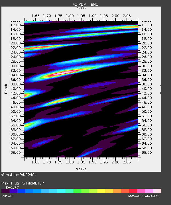
| Estimated Moho Depth: |
32.75 km |
| Estimated Crust Vp/Vs: |
1.77 |
| Assumed Crust Vp: |
6.264 km/s |
| Estimated Crust Vs: |
3.539 km/s |
| Estimated Crust Poisson's Ratio: |
0.27 |
|
| Radial Match: |
96.20494 % |
| Radial Bump: |
313 |
| Transverse Match: |
87.01425 % |
| Transverse Bump: |
400 |
| SOD ConfigId: |
414626 |
| Insert Time: |
2012-01-13 07:14:19.960 +0000 |
| GWidth: |
2.5 |
| Max Bumps: |
400 |
| Tol: |
0.001 |
|

Signal To Noise
| Channel | StoN | STA | LTA |
| AZ:RDM: :BHZ:20110824T17:55:14.124976Z | 158.0415 | 1.2553731E-5 | 7.943313E-8 |
| AZ:RDM: :BHN:20110824T17:55:14.124976Z | 34.57595 | 3.862471E-6 | 1.1170976E-7 |
| AZ:RDM: :BHE:20110824T17:55:14.124976Z | 31.79061 | 5.1198354E-6 | 1.6104866E-7 |
| Arrivals |
| Ps | 4.2 SECOND |
| PpPs | 14 SECOND |
| PsPs/PpSs | 18 SECOND |


