You are here: Home > Network List > CI - Caltech Regional Seismic Network Stations List
> Station ISA Isabella, Lake Isabella, CA, USA > Earthquake Result Viewer
ISA Isabella, Lake Isabella, CA, USA - Earthquake Result Viewer
| Earthquake location: |
Peru-Brazil Border Region |
| Earthquake latitude/longitude: |
-7.6/-74.5 |
| Earthquake time(UTC): |
2011/08/24 (236) 17:46:11 GMT |
| Earthquake Depth: |
147 km |
| Earthquake Magnitude: |
6.8 MB, 7.0 MW, 7.0 MW |
| Earthquake Catalog/Contributor: |
WHDF/NEIC |
|
| Network: |
CI Caltech Regional Seismic Network |
| Station: |
ISA Isabella, Lake Isabella, CA, USA |
| Lat/Lon: |
35.66 N/118.47 W |
| Elevation: |
873 m |
|
| Distance: |
59.7 deg |
| Az: |
319.116 deg |
| Baz: |
127.18 deg |
| Ray Param: |
0.061562065 |
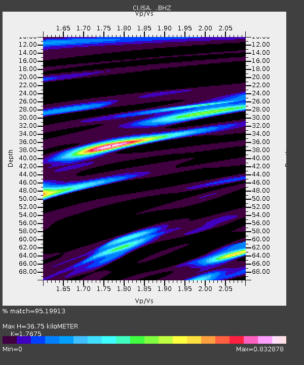
| Estimated Moho Depth: |
36.75 km |
| Estimated Crust Vp/Vs: |
1.77 |
| Assumed Crust Vp: |
6.1 km/s |
| Estimated Crust Vs: |
3.451 km/s |
| Estimated Crust Poisson's Ratio: |
0.26 |
|
| Radial Match: |
95.19913 % |
| Radial Bump: |
400 |
| Transverse Match: |
87.10004 % |
| Transverse Bump: |
400 |
| SOD ConfigId: |
414626 |
| Insert Time: |
2012-01-13 07:17:01.965 +0000 |
| GWidth: |
2.5 |
| Max Bumps: |
400 |
| Tol: |
0.001 |
|

Signal To Noise
| Channel | StoN | STA | LTA |
| CI:ISA: :BHZ:20110824T17:55:29.994971Z | 106.903435 | 8.55014E-6 | 7.9980026E-8 |
| CI:ISA: :BHN:20110824T17:55:29.994971Z | 67.18586 | 3.1217364E-6 | 4.6464187E-8 |
| CI:ISA: :BHE:20110824T17:55:29.994971Z | 32.90773 | 1.9347146E-6 | 5.87921E-8 |
| Arrivals |
| Ps | 4.8 SECOND |
| PpPs | 16 SECOND |
| PsPs/PpSs | 21 SECOND |


