You are here: Home > Network List > CI - Caltech Regional Seismic Network Stations List
> Station BC3 Big Chuckawalla Mtns, Desert Center, CA, USA > Earthquake Result Viewer
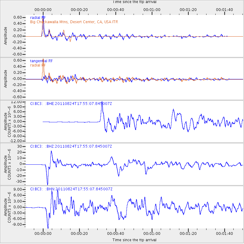
BC3 Big Chuckawalla Mtns, Desert Center, CA, USA - Earthquake Result Viewer
| Earthquake location: |
Peru-Brazil Border Region |
| Earthquake latitude/longitude: |
-7.6/-74.5 |
| Earthquake time(UTC): |
2011/08/24 (236) 17:46:11 GMT |
| Earthquake Depth: |
147 km |
| Earthquake Magnitude: |
6.8 MB, 7.0 MW, 7.0 MW |
| Earthquake Catalog/Contributor: |
WHDF/NEIC |
|
| Network: |
CI Caltech Regional Seismic Network |
| Station: |
BC3 Big Chuckawalla Mtns, Desert Center, CA, USA |
| Lat/Lon: |
33.66 N/115.45 W |
| Elevation: |
1137 m |
|
| Distance: |
56.5 deg |
| Az: |
319.064 deg |
| Baz: |
128.863 deg |
| Ray Param: |
0.063623615 |
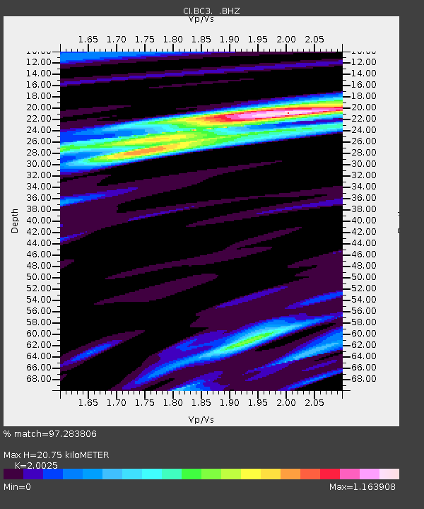
| Estimated Moho Depth: |
20.75 km |
| Estimated Crust Vp/Vs: |
2.00 |
| Assumed Crust Vp: |
6.155 km/s |
| Estimated Crust Vs: |
3.073 km/s |
| Estimated Crust Poisson's Ratio: |
0.33 |
|
| Radial Match: |
97.283806 % |
| Radial Bump: |
279 |
| Transverse Match: |
89.501686 % |
| Transverse Bump: |
400 |
| SOD ConfigId: |
414626 |
| Insert Time: |
2012-01-13 07:17:33.897 +0000 |
| GWidth: |
2.5 |
| Max Bumps: |
400 |
| Tol: |
0.001 |
|
Signal To Noise
| Channel | StoN | STA | LTA |
| CI:BC3: :BHZ:20110824T17:55:07.845007Z | 159.37073 | 1.383748E-5 | 8.682572E-8 |
| CI:BC3: :BHN:20110824T17:55:07.845007Z | 47.651173 | 4.5506117E-6 | 9.549842E-8 |
| CI:BC3: :BHE:20110824T17:55:07.845007Z | 65.194626 | 4.874245E-6 | 7.4764515E-8 |
| Arrivals |
| Ps | 3.5 SECOND |
| PpPs | 9.7 SECOND |
| PsPs/PpSs | 13 SECOND |


