You are here: Home > Network List > CI - Caltech Regional Seismic Network Stations List
> Station SWS Sam W. Stewart, Westmorland, CA, USA > Earthquake Result Viewer
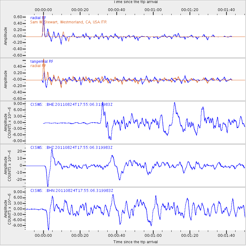
SWS Sam W. Stewart, Westmorland, CA, USA - Earthquake Result Viewer
| Earthquake location: |
Peru-Brazil Border Region |
| Earthquake latitude/longitude: |
-7.6/-74.5 |
| Earthquake time(UTC): |
2011/08/24 (236) 17:46:11 GMT |
| Earthquake Depth: |
147 km |
| Earthquake Magnitude: |
6.8 MB, 7.0 MW, 7.0 MW |
| Earthquake Catalog/Contributor: |
WHDF/NEIC |
|
| Network: |
CI Caltech Regional Seismic Network |
| Station: |
SWS Sam W. Stewart, Westmorland, CA, USA |
| Lat/Lon: |
32.94 N/115.80 W |
| Elevation: |
140 m |
|
| Distance: |
56.3 deg |
| Az: |
318.181 deg |
| Baz: |
128.187 deg |
| Ray Param: |
0.06376553 |
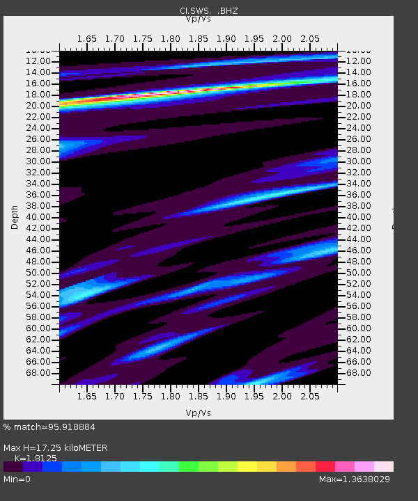
| Estimated Moho Depth: |
17.25 km |
| Estimated Crust Vp/Vs: |
1.81 |
| Assumed Crust Vp: |
6.155 km/s |
| Estimated Crust Vs: |
3.396 km/s |
| Estimated Crust Poisson's Ratio: |
0.28 |
|
| Radial Match: |
95.918884 % |
| Radial Bump: |
305 |
| Transverse Match: |
81.99853 % |
| Transverse Bump: |
400 |
| SOD ConfigId: |
414626 |
| Insert Time: |
2012-01-13 07:18:32.158 +0000 |
| GWidth: |
2.5 |
| Max Bumps: |
400 |
| Tol: |
0.001 |
|
Signal To Noise
| Channel | StoN | STA | LTA |
| CI:SWS: :BHZ:20110824T17:55:06.319983Z | 124.34884 | 1.3827181E-5 | 1.111967E-7 |
| CI:SWS: :BHN:20110824T17:55:06.319983Z | 28.165323 | 4.505309E-6 | 1.5995943E-7 |
| CI:SWS: :BHE:20110824T17:55:06.319983Z | 27.227934 | 4.1143003E-6 | 1.5110585E-7 |
| Arrivals |
| Ps | 2.4 SECOND |
| PpPs | 7.5 SECOND |
| PsPs/PpSs | 9.9 SECOND |


